Coasts: tides and currents
19 Slides9.47 MB
Coasts: tides and currents
Getting started You’ll need a notepad on which to make notes as you go along, or you could make notes, paste images, etc. on your device. You can view these slides: as a slide-show for any animations and to follow links in ‘normal’ view if you want to add call-outs or extra slides to make notes, paste images, answer questions. Geographical Association, 2020
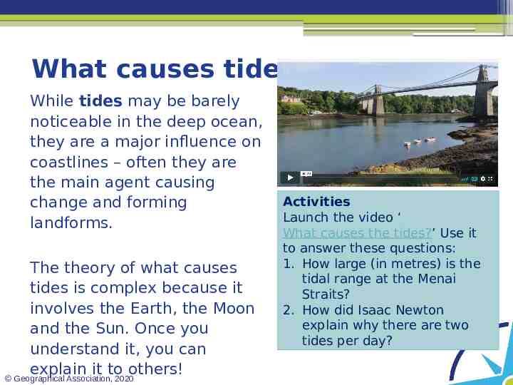
What causes tides? While tides may be barely noticeable in the deep ocean, they are a major influence on coastlines – often they are the main agent causing change and forming landforms. The theory of what causes tides is complex because it involves the Earth, the Moon and the Sun. Once you understand it, you can explain it to others! Geographical Association, 2020 Activities Launch the video ‘ What causes the tides?’ Use it to answer these questions: 1. How large (in metres) is the tidal range at the Menai Straits? 2. How did Isaac Newton explain why there are two tides per day?
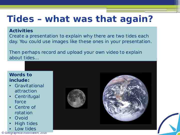
Tides – what was that again? Activities Create a presentation to explain why there are two tides each day. You could use images like these ones in your presentation. Then perhaps record and upload your own video to explain about tides Words to include: Gravitational attraction Centrifugal force Centre of rotation Ovoid High tides Low tides Geographical Association, 2020
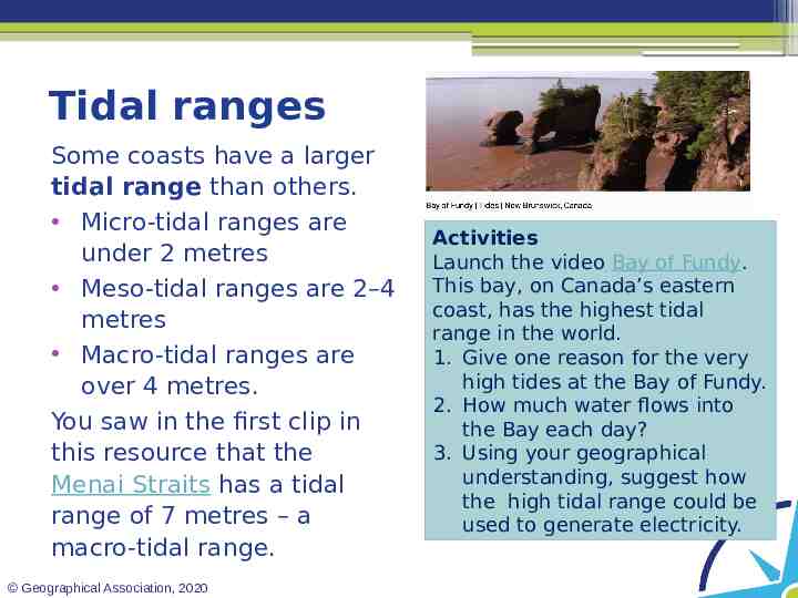
Tidal ranges Some coasts have a larger tidal range than others. Micro-tidal ranges are under 2 metres Meso-tidal ranges are 2–4 metres Macro-tidal ranges are over 4 metres. You saw in the first clip in this resource that the Menai Straits has a tidal range of 7 metres – a macro-tidal range. Geographical Association, 2020 Activities Launch the video Bay of Fundy. This bay, on Canada’s eastern coast, has the highest tidal range in the world. 1. Give one reason for the very high tides at the Bay of Fundy. 2. How much water flows into the Bay each day? 3. Using your geographical understanding, suggest how the high tidal range could be used to generate electricity.
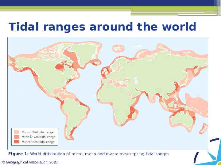
Tidal ranges around the world Figure 1: World distribution of micro, meso and macro mean spring tidal ranges Geographical Association, 2020
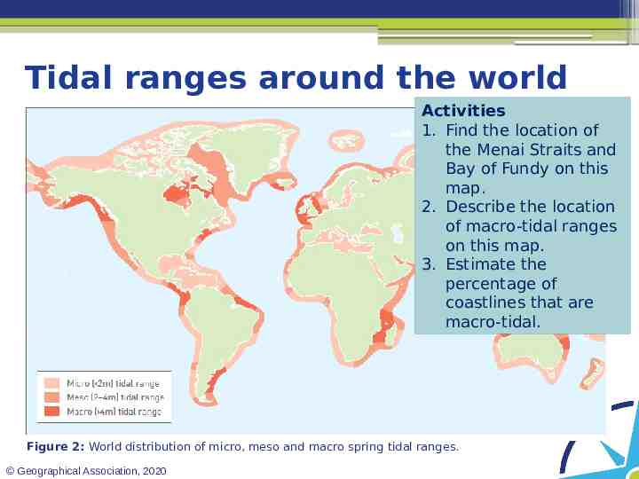
Tidal ranges around the world Activities 1. Find the location of the Menai Straits and Bay of Fundy on this map. 2. Describe the location of macro-tidal ranges on this map. 3. Estimate the percentage of coastlines that are macro-tidal. Figure 2: World distribution of micro, meso and macro spring tidal ranges. Geographical Association, 2020
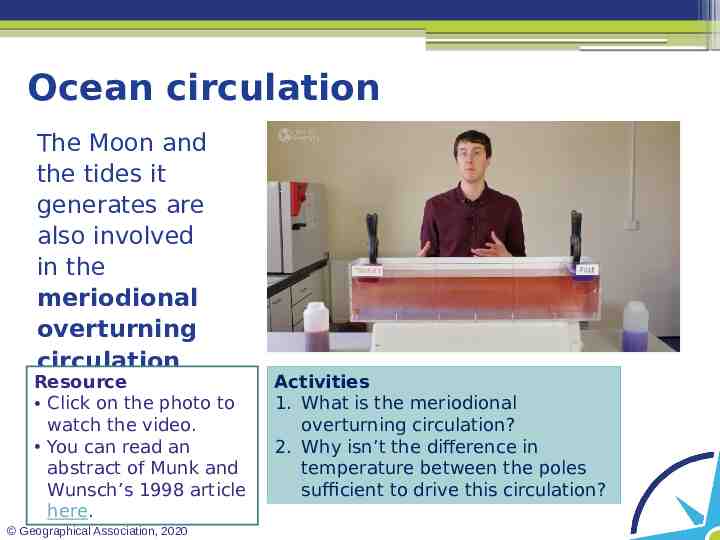
Ocean circulation The Moon and the tides it generates are also involved in the meriodional overturning circulation. Resource Click on the photo to watch the video. You can read an abstract of Munk and Wunsch’s 1998 article here. Geographical Association, 2020 Activities 1. What is the meriodional overturning circulation? 2. Why isn’t the difference in temperature between the poles sufficient to drive this circulation?
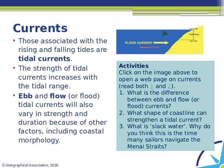
Currents Those associated with the rising and falling tides are tidal currents. The strength of tidal currents increases with the tidal range. Ebb and flow (or flood) tidal currents will also vary in strength and duration because of other factors, including coastal morphology. Geographical Association, 2020 Activities Click on the image above to open a web page on currents (read both 1 and 2). 1. What is the difference between ebb and flow (or flood) currents? 2. What shape of coastline can strengthen a tidal current? 3. What is ‘slack water’. Why do you think this is the time many sailors navigate the Menai Straits?
Coastal effects of tides Tides have several important effects, including: The change in sea level means different parts of the shore are exposed to marine processes. Tidal currents can erode and deposit material on the shore as the water ebbs and flows. Tidal currents are important in the transportation of sediment. Ebb and flow currents sometimes follow different routes, influencing sediment cell circulation. Geographical Association, 2020 Activities 1. Name a coastal landform that would be influenced by high and low tides. Explain how tides are involved in its formation. 2. ‘Asymmetry’ in ebb and flow currents means that one direction of current moves more water and transports more sediment than the other. Explain how this could be involved in the circulation of sediment within a sediment cell. 3. Name other transportation processes involved in sediment circulation.
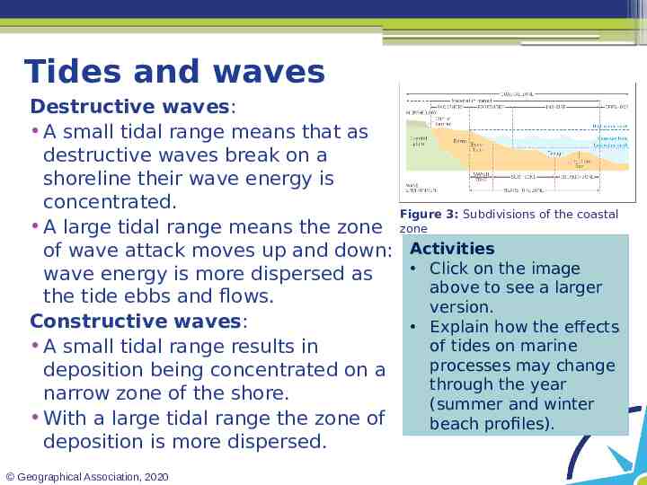
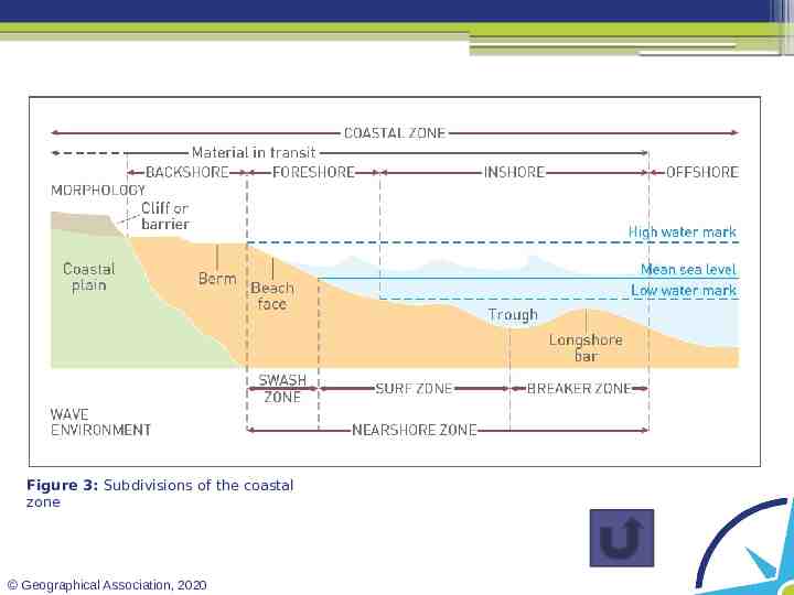
Tides and waves Destructive waves: A small tidal range means that as destructive waves break on a shoreline their wave energy is concentrated. Figure 3: Subdivisions of the coastal A large tidal range means the zone zone of wave attack moves up and down: Activities Click on the image wave energy is more dispersed as above to see a larger the tide ebbs and flows. version. Constructive waves: Explain how the effects of tides on marine A small tidal range results in processes may change deposition being concentrated on a through the year narrow zone of the shore. (summer and winter With a large tidal range the zone of beach profiles). deposition is more dispersed. Geographical Association, 2020
Figure 3: Subdivisions of the coastal zone Geographical Association, 2020
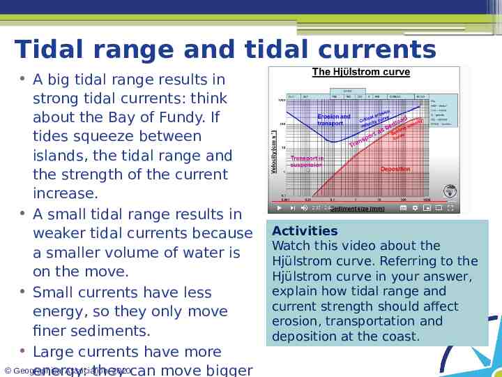
Tidal range and tidal currents A big tidal range results in strong tidal currents: think about the Bay of Fundy. If tides squeeze between islands, the tidal range and the strength of the current increase. A small tidal range results in weaker tidal currents because a smaller volume of water is on the move. Small currents have less energy, so they only move finer sediments. Large currents have more Geographical Association, 2020can move bigger energy: they Activities Watch this video about the Hjülstrom curve. Referring to the Hjülstrom curve in your answer, explain how tidal range and current strength should affect erosion, transportation and deposition at the coast.
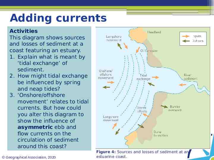
Adding currents Activities This diagram shows sources and losses of sediment at a coast featuring an estuary. 1. Explain what is meant by ‘tidal exchange’ of sediment. 2. How might tidal exchange be influenced by spring and neap tides? 3. ‘Onshore/offshore movement’ relates to tidal currents. But how could you alter this diagram to show the influence of asymmetric ebb and flow currents on the circulation of sediment around this coast? Geographical Association, 2020 Figure 4: Sources and losses of sediment at an estuarine coast.
Taking it further Coastal resilience and vulnerability: storm impacts, extreme weather and regional variability in the UK, winter 2013–14. In this article Sue Brooks highlights how new technologies are being used to quantify the impacts of the stormy winter of 2013–14 on UK coastlines, focusing on the wave-dominated coastline of the south-west and the tidedominated coastline of East Anglia. Geographical Association, 2020 Reflection How do atmospheric pressure, waves and tides interact to create surges – and how do we know? Contrast the characteristics and impact of the wavedominated coastal processes of the south-west coastline and the tide-dominated processes in East Anglia. Define the NAO and explain why it is associated with coastal erosion in the UK.
Summary Tides are caused by the movement around each other of the Moon and the Earth, by the Earth’s spin and because of the Sun’s weak gravitational effect. Tides are not uniform along all coasts – there are differences in tidal range, usually because of the shape of the coastline. Tides turned out to be the answer to the puzzle of what kept the meriodional overturning circulation turning over. Tides move water up and down, but they also generate movement towards and away from the land – tidal currents. Tides and tidal currents have a very significant impact on coastal processes. Geographical Association, 2020
Glossary Ebb currents: currents that move away from the land. Flow (or flood) currents: currents that move towards the land. Meriodional overturning circulation: the global circulation cell of water between the Equator and the poles. Sediment cell: areas along the coastline with a selfcontained movement of sediment: a closed system. Tidal currents: horizontal movements of water caused by the rise and fall of tides. Tidal range: the difference in height (vertical) between high tide and low tide. Tides: the rise and fall of sea levels caused by the gravitational pull of the Moon and Sun combined with the Earth’s spin. Geographical Association, 2020
Links From the awarding bodies Topic AQA 3.1.3 Coastal systems and landscapes Eduqa A 1.1 Coastal landscapes s Edexce 2B: Coastal Landscapes l and Change OCR 1.1.1 Coastal Landscapes WJEC A 1.1 Coastal landscapes CCEA C 1: Coastal processes and features. Geographical Association, 2020 Further reading Top Spec Geography: Coast s , by Debbie Milton and Gerd Masselink, published by the GA. Time for Geography: Coasts The BBC publishes Tide Tables which show the times and predicted heights of high and low tides around UK coasts. Any questions about tides? The NTSLF probably has the answers For the full Hjülstrom experience explore the GEO unit Physical processes.
Acknowledgements This presentation has been written by Rob Bircher, an experienced author, publisher and secretary of the Worcester Branch of the GA. Figures Slide 4: Photos source: https://en.wikipedia.org/wiki/Moon#/media/File:FullMoon2010.jpghttps:// en.wikipedia.org/wiki/Moon#/media/File:FullMoon2010.jpg Slides 6 and 7: Figures 1 and 2: Top Spec Geography: Coasts (2018) by Gerd Masselink and Debbie Milton, Geographical Association, p. 15 Slides 11 and 12: Figure 3, source as above, p. 6 Slide 14: Figure 4, source as above, p. 9 Geographical Association, 2020