Experiments conducted under NOAA’s Climate Test Bed
52 Slides3.50 MB
Experiments conducted under NOAA’s Climate Test Bed Subseasonal Prediction with the NCEP-CFS: Forecast Skill and Prediction Barriers for Tropical Intraseasonal Oscillations Augustin Vintzileos and Hua-Lu Pan EMC/NCEP/NWS/NOAA
Messages to take back home The CFS is a useful tool in forecasting Tropical Intraseasonal Oscillations which are the basis for subseasonal prediction– its skill is similar to other centers The reason for the drop in skill is found in the Maritime Continent which presents a Barrier to the eastward propagation of the active convective phase of the TIO Increasing the horizontal resolution of the atmospheric model has not improved the skill of TIO forecast A better set of initial conditions is shown to be crucial for improving skill by 3-5 days. Both better quality and better compatibility with the forecast model appears to be a factor Intraseasonal variations of oceanic initial states are not well represented by GODAS. However, ocean – atmosphere coupling is quite important for the TIO. It follows that inconsistencies between the ocean and atmospheric initial state at this portion of the spectrum may damage the forecast

What is Subseasonal Forecasting?
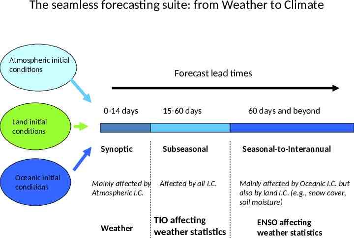
The seamless forecasting suite: from Weather to Climate Atmospheric initial conditions Forecast lead times 0-14 days 15-60 days 60 days and beyond Land initial conditions Synoptic Oceanic initial conditions Mainly affected by Atmospheric I.C. Weather Subseasonal Affected by all I.C. TIO affecting weather statistics Seasonal-to-Interannual Mainly affected by Oceanic I.C. but also by land I.C. (e.g., snow cover, soil moisture) ENSO affecting weather statistics
Issues concerning subseasonal forecasting: How critical are Initial Conditions? How critical is model resolution? How critical are model drifts and biases? What are the most adequate ensemble generation techniques? Answers to such questions will allow to prioritize development efforts and thus optimize the operational tool
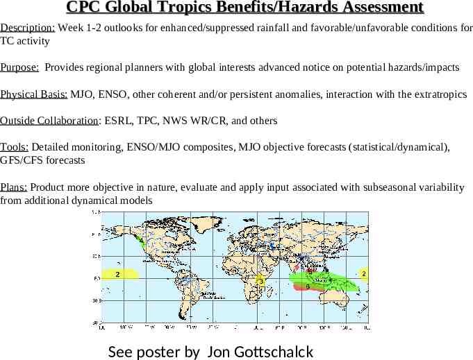
CPC Global Tropics Benefits/Hazards Assessment Description: Week 1-2 outlooks for enhanced/suppressed rainfall and favorable/unfavorable conditions for TC activity Purpose: Provides regional planners with global interests advanced notice on potential hazards/impacts Physical Basis: MJO, ENSO, other coherent and/or persistent anomalies, interaction with the extratropics Outside Collaboration: ESRL, TPC, NWS WR/CR, and others Tools: Detailed monitoring, ENSO/MJO composites, MJO objective forecasts (statistical/dynamical), GFS/CFS forecasts Plans: Product more objective in nature, evaluate and apply input associated with subseasonal variability from additional dynamical models See poster by Jon Gottschalck

The Tropical Intraseasonal Oscillation (TIO)
Tropical Intraseasonal Oscillations: some points to remember TIO consists of large-scale coupled patterns in atmospheric circulation and deep convection all propagating eastward slowly through the portion of the Indian and Pacific oceans where the sea surface is warm. It constantly interacts with the underlying ocean and influences many weather and climate systems (from Zhang, 2005) TIO are the scientific basis for subseasonal forecasting i.e., they are what ENSO is to seasonal forecasting No theoretical context yet Comprehensive dynamical models do not represent them perfectly though there is consensus that coupling with the ocean improves their simulation Observations show that sometimes the MJO collapses to higher modes as it crosses the Maritime Continent
Defining a metric for the TIO A CLIVAR-MJO panel recently made recommendations on a number of metrics to use. One of these metrics combine winds at 200 hPa and 850 hPa and precipitation i.e., represents the coupling between the large scale circulation and diabatic forcing. We have hindcasts from 2002 to 2006 i.e., a mostly quiet period in regard to ENSO events. Nevertheless, in order to avoid possible sampling issues for defining mean annual cycles and drifts we only use the smoothest possible variable for defining an index. We use zonal wind at 200 hPa averaged from 20 S-20 N and we next show that for our purpose this is an adequate measure
Defining a metric for the TIO The Recipe Our verifying fields will be from Reanalysis-2 Consider the zonal wind at 200 hPa from 2002 to 2006 averaged between 20 S-20 N Compute and remove the mean annual cycle and the zonal mean Perform and EOF analysis of the resulting field (no time filtering)
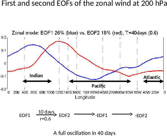
First and second EOFs of the zonal wind at 200 hPa Indian Atlantic Pacific EOF1 10 days EOF2 r 0.6 -EOF1 A full oscillation in 40 days -EOF2
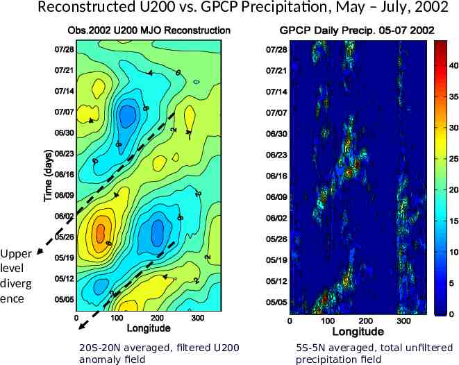
Reconstructed U200 vs. GPCP Precipitation, May – July, 2002 Upper level diverg ence 20S-20N averaged, filtered U200 anomaly field 5S-5N averaged, total unfiltered precipitation field
Defining a metric for the TIO The Recipe Projection of the observed and forecast U200 anomalies on the two first EOFs isolates the TIO signal (no filtering in the time domain) Pattern correlation between the observed and forecast projections
Some initial experimentation Used the T126 version of the operational T62 CFS Hindcasts were run up to 65 days and were initialized four times per day from CDAS2 and GODAS from May 7th to July 15th and from November 7th to January 15th from 2000 to 2004 (run by Saha, Vintzileos, Thiaw and Johanson )

The Maritime Continent Barrier
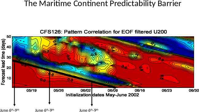
Pattern Correlation for initialization dates from May to June 2002 The Maritime Continent Predictability Barrier June 6th-9th June 6th-9th June 6th-9th
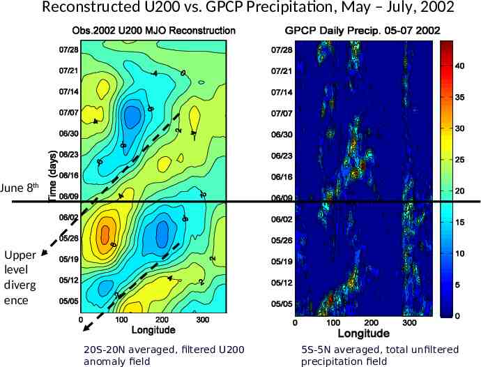
Reconstructed U200 vs. GPCP Precipitation, May – July, 2002 June 8th Upper level diverg ence 20S-20N averaged, filtered U200 anomaly field 5S-5N averaged, total unfiltered precipitation field
We designed a series of subseasonal retrospective forecasts with the CFS for the systematic study of the Maritime Continent Barrier (Proposed to and endorsed by the Climate Test Bed FY2007)
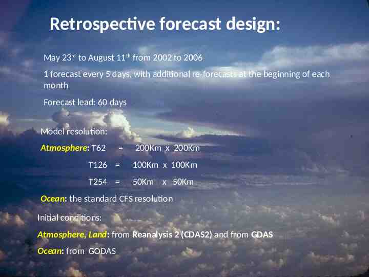
Retrospective forecast design: May 23rd to August 11th from 2002 to 2006 1 forecast every 5 days, with additional re-forecasts at the beginning of each month Forecast lead: 60 days Model resolution: Atmosphere: T62 200Km x 200Km T126 100Km x 100Km T254 50Km x 50Km Ocean: the standard CFS resolution Initial conditions: Atmosphere, Land: from Reanalysis 2 (CDAS2) and from GDAS Ocean: from GODAS

Forecast skill for TIO as a function of Resolution and Initial Conditions
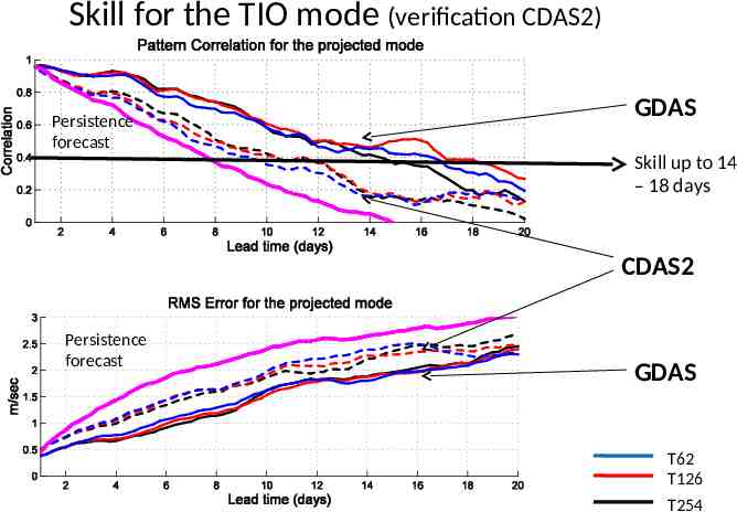
Skill for the TIO mode (verification CDAS2) Persistence forecast GDAS Skill up to 14 – 18 days CDAS2 Persistence forecast GDAS T62 T126 T254
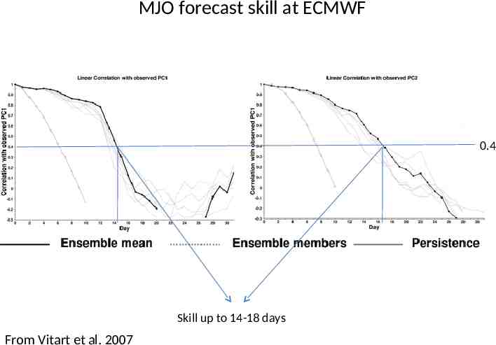
MJO forecast skill at ECMWF 0.4 Skill up to 14-18 days From Vitart et al. 2007

Reasons for the drop in forecast skill: The Maritime Continent Barrier
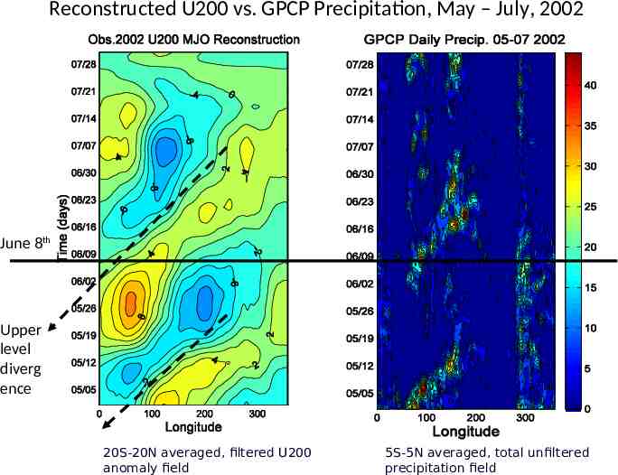
Reconstructed U200 vs. GPCP Precipitation, May – July, 2002 June 8th Upper level diverg ence 20S-20N averaged, filtered U200 anomaly field 5S-5N averaged, total unfiltered precipitation field
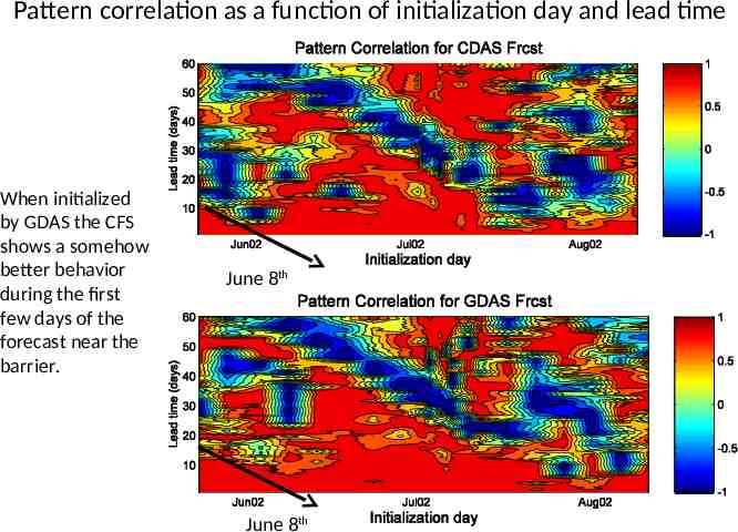
Pattern correlation as a function of initialization day and lead time When initialized by GDAS the CFS shows a somehow better behavior during the first few days of the forecast near the barrier. June 8th June 8th
and the Ocean? There is consensus that the ocean plays an important role for the evolution of the TIO CFS is initialized by GODAS which in turn is optimized for Seasonal-to-Interannual forecast GODAS: – Comes in pentads – Its SST is damped to the weekly Reynolds SST – Contains information from 2 weeks before and two weeks after
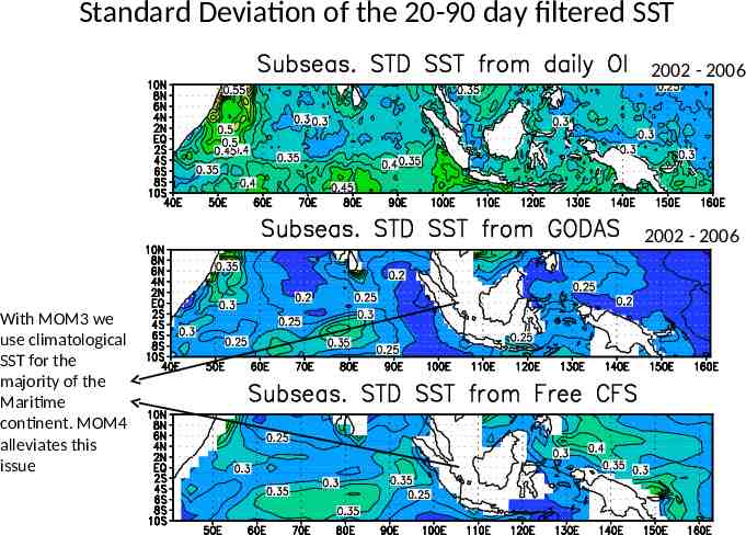
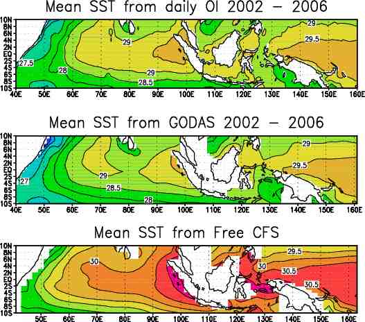
Standard Deviation of the 20-90 day filtered SST 2002 - 2006 2002 - 2006 With MOM3 we use climatological SST for the majority of the Maritime continent. MOM4 alleviates this issue
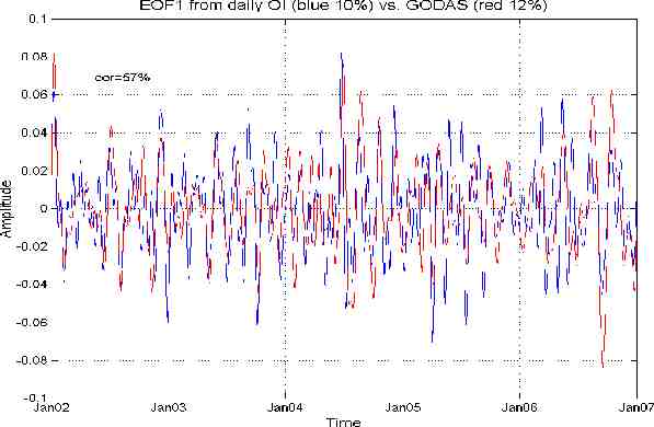
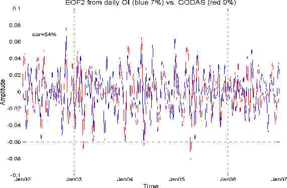
As suspected, energy in the subseasonal portion of the spectrum is low in the GODAS product What about the normalized variability modes (more physical meaning for the Indian Ocean than simple EOFs) ?
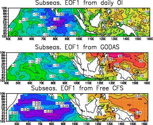
Is there any relevance between the daily OI SST EOF modes and the TIO?
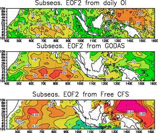
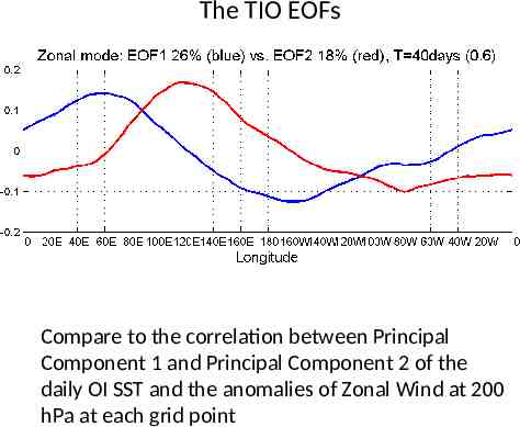
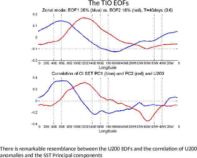
The TIO EOFs Compare to the correlation between Principal Component 1 and Principal Component 2 of the daily OI SST and the anomalies of Zonal Wind at 200 hPa at each grid point
The TIO EOFs There is remarkable resemblance between the U200 EOFs and the correlation of U200 anomalies and the SST Principal components
There is an empirical relationship between the SST and the TIO suggesting that initial states for the ocean and the atmosphere should be coherent
Messages The CFS is a useful tool for forecasting Tropical Intraseasonal Oscillations – its skill is similar or better to other centers The reason for the drop in skill is found in the Maritime Continent which presents a Barrier to the eastward propagation of the active convective phase of the TIO Increasing the horizontal resolution of the atmospheric model has not improved the skill of TIO forecast A better set of initial conditions is shown to be crucial for improving skill by 3-5 days. Both better quality and better compatibility with the forecast model appear to be a factor Intraseasonal variations of oceanic initial states are not well represented by GODAS. However, ocean – atmosphere coupling is quite important for the TIO. It follows that inconsistencies between the ocean and atmospheric initial state at this portion of the spectrum may damage the forecast
Conclusions We have shown that a set of atmospheric initial conditions which is more realistic and which is more compatible with the forecast model is crucial for TIO forecast. This underlines the importance of the new reanalysis project carried out at NCEP. We have shown here that horizontal resolution is not critical for forecast of the TIO. However there are areas (Sahel) were resolution higher than T126 is beneficial. The next version of the CFS will be at T126. Could downscaling from T126 provide results as good as the ones obtained with a CFS at T254 in these areas? The role of oceanic initial conditions has not yet been explored. How to improve the intraseasonal part of the ocean initial state?
Questions?
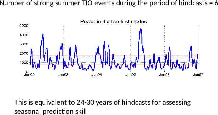
Number of strong summer TIO events during the period of hindcasts 6 This is equivalent to 24-30 years of hindcasts for assessing seasonal prediction skill

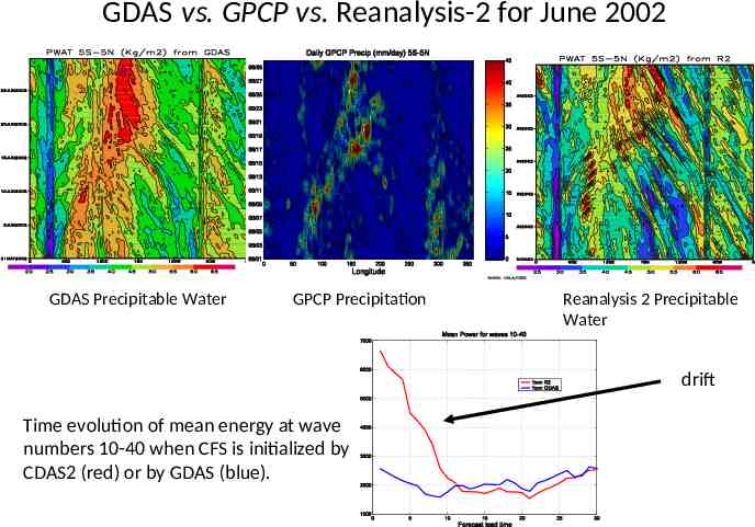
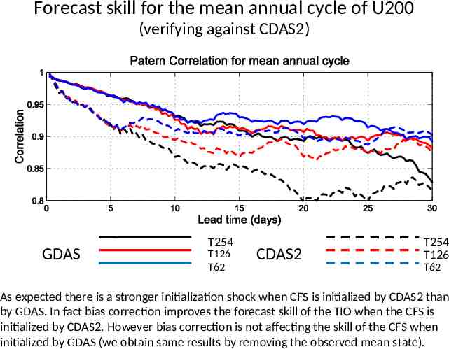
Initialization shocks The GDAS initial conditions are more compatible to the CFS atmosphere than CDAS2 This difference could result to a stronger initialization shock when CFS is initialized by CDAS2 We quantify the initialization shock by investigating forecast skill for the mean annual cycle
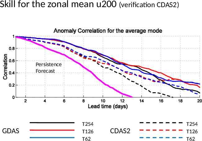
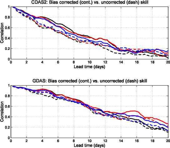
Forecast skill for the mean annual cycle of U200 (verifying against CDAS2) GDAS T254 T126 T62 CDAS2 T254 T126 T62 As expected there is a stronger initialization shock when CFS is initialized by CDAS2 than by GDAS. In fact bias correction improves the forecast skill of the TIO when the CFS is initialized by CDAS2. However bias correction is not affecting the skill of the CFS when initialized by GDAS (we obtain same results by removing the observed mean state).
Tropical Atlantic
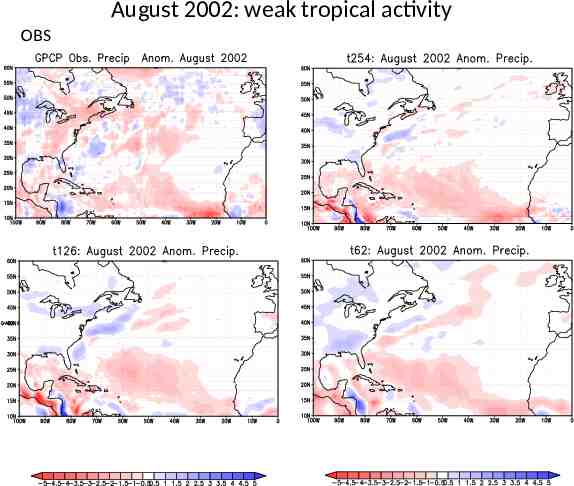
August 2002: weak tropical activity OBS
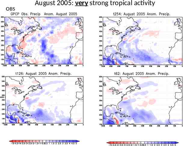
OBS August 2005: very strong tropical activity

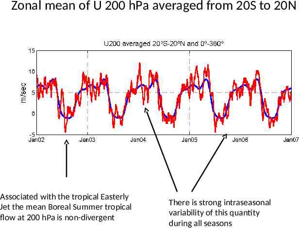
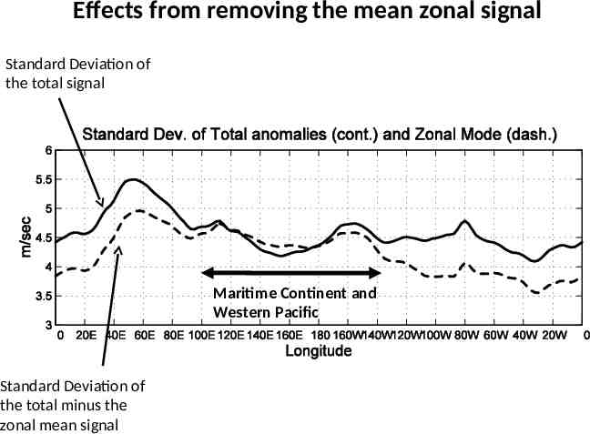
Zonal mean of U 200 hPa averaged from 20S to 20N Associated with the tropical Easterly Jet the mean Boreal Summer tropical flow at 200 hPa is non-divergent There is strong intraseasonal variability of this quantity during all seasons
Effects from removing the mean zonal signal Standard Deviation of the total signal Maritime Continent and Western Pacific Standard Deviation of the total minus the zonal mean signal
Skill for the zonal mean u200 (verification CDAS2) Persistence Forecast GDAS T254 T126 T62 CDAS2 T254 T126 T62
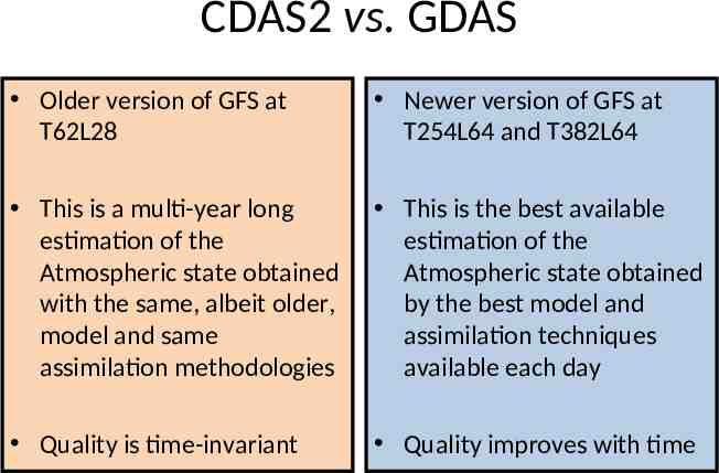
CDAS2 vs. GDAS Older version of GFS at T62L28 Newer version of GFS at T254L64 and T382L64 This is a multi-year long estimation of the Atmospheric state obtained with the same, albeit older, model and same assimilation methodologies This is the best available estimation of the Atmospheric state obtained by the best model and assimilation techniques available each day Quality is time-invariant Quality improves with time
GDAS vs. GPCP vs. Reanalysis-2 for June 2002 GDAS Precipitable Water GPCP Precipitation Reanalysis 2 Precipitable Water drift Time evolution of mean energy at wave numbers 10-40 when CFS is initialized by CDAS2 (red) or by GDAS (blue).
