Evolution of Oil Production in the Bakken Formation Julie A. LeFever


34 Slides3.98 MB
Evolution of Oil Production in the Bakken Formation Julie A. LeFever North Dakota Geological Survey
Plays of the Bakken Formation Conventional Bakken (pre-1987) Cycle 1 – Antelope Structure (1950s – 60s) Cycle 2 – Depositional Edge (1970s – 80s) Horizontal Drilling of the Bakken Shale (post-1987) Horizontal Drilling of the Bakken Middle Member (2001 to present)
Conventional Bakken Cycle 1 – Antelope Field Discovery Well Stanolind - #1 Woodrow Starr Initial Potential (536 BO; 0.1 BW) Antelope Field 52 wells; 12.5 million BO; 10 BCF Gas “Sanish Sand” Completion Method
Conventional Bakken Exploration between Cycles Elkhorn Ranch Shell Oil Co. - #41X-5-1 Government Nesson Anticline #1 B.E. Hove IP - 756 BOPD, 3 BWPD Completion Method
Conventional Bakken Cycle 2 – Depositional Limit Stratigraphy & Structure Thin Bakken Multiple Pays Folds, Faults or Both Completion Methods
Horizontal Drilling of the Upper Bakken Shale Meridian - #33-11 MOI Drilled vertical Cored, Logged, Drill Stem Tested Drilled Horizontally - 2603 ft 8 ft - upper Bakken Shale IP: 258 BOPD & 299 MCF gas Cost: 2 million
Learning Curve Meridian -#33-11 MOI 57 days to drill 27 days to drill vertical borehole 12 days to drill horizontal section 2 million 3 set of 10 wells 35 days to drill at a cost 1.08 million End of Play 900,000 (same as a vertical well)
Horizontal Drilling of the Upper Bakken Shale Drilling Methods General Problems Successful well high volumes of oil
Horizontal Drilling of the Bakken Middle Member Richland County, Montana North Dakota
Williston Basin AB SK MB MT ND SD . Co e zi en cK M d an hl ic R . Co MT WY ND Study Area
Richland County, MT Stratigraphy Upper Shale Member Transitional Facies – L7 Lower 2 Devonian Three Forks ies ac of th Li Upper (Productive) Transitional Facies - L1 Lower Shale Member North Mississippian Bakken Formation South Mississippian Lodgepole Formation
Balcron Oil - #44-24 Vaira SESE Sec. 24, T.24N., R.54E. GR Density Porosity upper 1000 0 Bakken Fm. Lodgepole Fm. middle Three Forks Fm. Neutron Porosity
10604.5 ft. SESW Sec. 13, T.23N.,R.56E. AHEL #1 H8 Nevins Richland County, MT Bakken/Three Forks Contact
SESW Sec. 13, T.23N.,R.56E. AHEL #1 H8 Nevins Richland County, MT Middle Member Lithofacies 2
SESW Sec. 13, T.23N.,R.56E. AHEL #1 H8 Nevins Richland County, MT Middle Member Lithofacies 2 (producing facies)
10582 ft SESW Sec. 13, T.23N.,R.56E. AHEL #1 H8 Nevins Richland County, MT Upper Shale/Middle Mbr Contact
Contour Interval BLCS Structure Map Montana North Dakota -57 00 -58 00 -59 00 -60 00 -61 00 -62 00 -63 00 -64 00 -65 00 -66 00 -67 00 -68 00 -69 00 -70 00 -71 00 -72 00 -73 00 -74 00 -75 00 ft
Formation Limits Bakken Formation Upper Middle Lower Prairie Salt Edge ? Montana North Dakota
Contour Interval Isopach of the Bakken Formation Montan a North Dakota 140f 130t 120 110 100 90 80 70 60 50 40 30 20 10 0
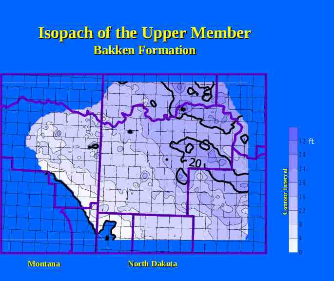
Isopach of the Upper Member Bakken Formation 3 2 ft Contour Interval 28 24 20 16 12 8 4 0 Montana North Dakota
Isopach of the Middle Member Bakken Formation 7 0 6 5 Contour Interval 6 0 5 5 5 0 4 5 4 0 3 5 3 0 2 5 2 0 1 5 1 0 5 0 Montana North Dakota ft
Middle Member Porosity Zone Ri ch la nd M cK en zi e Co . Co . Contour Interval 12 10 8 6 4 2 0 Contour Interval: 2 ft. %
Bakken Middle Member Prairie Salt Prairie Salt Edge 7 0 6 5 6 0 Contour Interval 5 5 5 0 4 5 4 0 3 5 3 0 2 5 2 0 1 5 1 0 5 0 Montana North Dakota ft
Bakken Middle Member Prairie Salt Prairie Salt 7 0 6 5 6 0 Contour Interval 5 5 5 0 4 5 4 0 3 5 3 0 2 5 2 0 1 5 1 0 5 0 Montana North Dakota ft
Richland County 80 Producing Fields 1. Red River Fm 2. Madison Fm 3. Bakken Fm 4. Duperow Fm 5. Interlake Fm 20 Fields produce(d) from the Bakken Formation 08/2004
Bakken Formation Richland County, MT Historically – 42 Bakken wells 8 commingled wells Currently – 127 Bakken Producers Horizontals – 92 producers, 1 PNA, 1 Dry Total production 2000 – 2,618,982 BO 2003 – 5,284,378 BO 2004 – 3,275,061 BO (thru August, 2004) 86 Producing Fields, 23 - Bakken Production 08/2004
Drilling & Completion Bakken Horizontals Two laterals to a 1280 spacing unit Well is stimulated with large fracture treatment ( 920,000#, gelled water/sand frac) Cost 2.2 million 500-700 BOPD initially Virtually no water
Horizontal Drilling of the Bakken Middle Member Richland County, Montana North Dakota
Lithofacies of the Middle Member Upper Shale Lithofacies 5 - Siltstone Lithofacies 4 – Interbedded Dark Grey Shale and Buff Silty Sandstone Lithofacies 3 - Sandstone Productive Lithofacies 2 – Interbedded Dark Grey Shale and Buff Silty Sandstone Productive in MT Lithofacies 1 - Siltstone Lower Shale (From LeFever and others, 1991)
Lithofacies 3
SENW Sec. 11, T160N, R95W Conoco, Inc. - #17 Watterud “A” GR Res Producing Zone Upper L2 Facies
Joilette Oil (USA), LLC. #1-17R Robert Heuer Sadler Field Re-entry of a Madison Test (02/13/1981) Bakken Completion 03/05/2004 IP – 87 BOPD, 150 MCF, 142 BWPD Fracture Stimulated Producing Zone – Lithofacies 3
What Do We Know? Rocks Types (Montana North Dakota) Additional Productive Section Lithofacies 3, “Sanish”, lower Lodgepole Limestone Salt Collapse Completion Methods High Production Rates
Conclusions Horizontal Drilling Middle Member Success