Electronic Charting: Introduction to OpenCPN Supplement to: Chapter


66 Slides6.46 MB
Electronic Charting: Introduction to OpenCPN Supplement to: Chapter 5 Section 18 Charts 2019 United States Power Squadrons
OpenCPN Basics OpenCPN Is a free open-source application This module should familiarize you with: Electronic charting displays Electronic charting functions Learning objectives OpenCPN installation Downloading and installing charts Placing and manipulating waypoints Creating routes Utilizing route and waypoint manager functions 2019 United States Power Squadrons 2
Downloading OpenCPN Downloading: Type http://opencpn.org/ into your internet browser Or “google” OpenCPN and follow links to above site Press Enter 3 2019 United States Power Squadrons
Downloading OpenCPN (2) From the OpenCPN home page Select and Left Click “Downloads” from the menu bar at the top of the page. 5th option from the left 4 2019 United States Power Squadrons
Downloading OpenCPN (3) Click on OpenCPN Latest Release or Current Version Note Location of Plugins Same thing Optional features that can be added to OpenCPN Note User Manual is bundled with OpenCPN 5 2019 United States Power Squadrons
Downloading OpenCPN (4) Download OpenCPN page will open Select the software version for your computer's operating system. Windows 7/8/8.1/10 “Click” (Download) under Windows Mac OS X 10.7 “Click” (Download) under Mac Older versions are supported Other Operating Systems are also supported Follow the directions indicated 6 2019 United States Power Squadrons
Installing OpenCPN Windows Find the OpenCPN installation file in your computer’s Downloads folder and follow the procedure for installing apps on your computer. For Windows computers this usually is a matter of double clicking the file and following the on-screen instructions. Apple OpenCPN will marked as an app from an unidentified developer To override this: Control-click the app choose Open from the menu in the dialog that appears, click Open Enter your administrator name and password when prompted. The app is now saved as an exception to your security settings 7 2019 United States Power Squadrons
Installing OpenCPN (2) Detailed installation guides are available online for the following operating systems: Windows Ubuntu PPA Linux Fedora Mac OS X Dedicated Marine OS Orange Pi RaspberryPI RPI2 8 2019 United States Power Squadrons
Installing OpenCPN (3) From the OpenCPN home page Select and Left Click “Start” from the menu bar at the top of the page. 3rd option from the left 9 2019 United States Power Squadrons
Installing OpenCPN (4) Detailed Help Downloading and Installing OpenCPN Downloading and Installing Charts Setup Your GPS 10 2019 United States Power Squadrons
Global Toolbar Hide/Expand Tool Bar Options Create Route (Ctrl-R) Route and Mark Manager Enable Tracking Change Color Schemes Print Chart About OpenCPN Drop MOB Marker (Ctrl-Space) 11 2019 United States Power Squadrons
Setting Options For now, select these settings North Up - Blue Course Up - Red No GPS fix - Red GPS fix - Green Compass / GPS Status Window Chart Panel Toolbar Zoom In/Out Chart Scale Expand/Hide Chart Panel Options Box 12 2019 United States Power Squadrons
Setting Options (2) Left Click Options Button Set these units as shown Left Click Apply OK 13 2019 United States Power Squadrons
Setting Options (3) Left Click Options Button Units File Tab Set these units as shown Note: Disable WMM plugin to set variation Left Click Apply OK 14 2019 United States Power Squadrons
Setting Options (4) Left Click Options Button User Interface Set the interface options as shown Left Click Apply OK 15 2019 United States Power Squadrons
Getting Charts Start OpenCPN program Left Click the Options icon Left Click on the Charts tab 16 2019 United States Power Squadrons
Getting Charts (2) Left Click on “Chart Downloader” file tab 17 2019 United States Power Squadrons
Getting Charts (3) Left Click on “Add” 18 2019 United States Power Squadrons
Getting Charts (4) Left Click on the “ ” next to the “NOAA & Inland charts” folder 19 2019 United States Power Squadrons
Getting Charts (5) Left Click on the “ ” next to the “RNC” folder 20 2019 United States Power Squadrons
Getting Charts (6) Left Click on the “ ” next to the “by States” folder 21 2019 United States Power Squadrons
Getting Charts (7) Scroll down to the state you want to download – use your home state 22 2019 United States Power Squadrons
Getting Charts (8) Left Click anywhere on the line from the open book through the end of the state name Left Click “Select a folder” 23 2019 United States Power Squadrons
Getting Charts (9) By default you will be brought to your “Documents” folder or its equivalent in other operating systems If that is acceptable Left Click “OK” If not, you need to: Create a folder on your computer Place it where you can find it in the future Name the folder 2 suggestions are Charts BSBChart 24 2019 United States Power Squadrons
Getting Charts (10) Re-check that chosen state is highlighted Left Click “OK” 25 2019 United States Power Squadrons
Getting Charts (11) Left Click “Update” 26 2019 United States Power Squadrons
Getting Charts (12) Choose the ü charts you ü want by Left Clicking in Select all boxes Deselect all Or Right Click Invert here to open selection the context Select menu updated Select new Left Click on “Download selected charts” 27 2019 United States Power Squadrons
Getting Charts (13) Check both boxes in the Update Control Left Click on Prepare all “ENC Charts” Left Click “Apply” Left Click “OK” ü ü 28 2019 United States Power Squadrons
Sample Exercise 1-1 In exercise 1-1 in Section 17 we were asked to find the latitude and longitude of positions A, B, and C on the Bowditch Bay sample chart. We found: “A” was at: We can use these 3 positions and L 41 37.1′ N create waypoints in OpenCPN Lo 072 01.1′ W This method will work whenever you “B” was at: know the latitude and longitude of a L 41 43.0′ N waypoint Lo 072 02.8′ W Using the same method but visually “C” was at: placing the waypoint will allow you to L 41 37.8′ N determine the coordinates of that Lo 071 54.4′ W location using the Waypoint Properties 29 2019 United States Power Squadrons
Sample Exercise 1-1 (2) Pull up the correct chart Estimate the waypoint location L 41 37.1′ N Lo 072 01.1′ W Right Click at your estimated location Left Click on “Drop Mark” or use the keyboard shortcut CtrlM 30 2019 United States Power Squadrons
Sample Exercise 1-1 (3) Right Click on the new Waypoint Right click on “Properties ” 31 2019 United States Power Squadrons
Sample Exercise 1-1 (4) Under Waypoint Properties you can change: Name – A Icon – Symbol –Star – Green Latitude - 41 37.1′ N Longitude - 072 01.1′ W Description – Add any information you might wish to save for reference Links – Links to sites describing waypoint Click OK The Waypoint will move to the correct location 2019 United States Power Squadrons 32
Sample Exercise 1-1 (5) Repeat the process for Point B Drop a Waypoint near L 41 43.0′ N Lo 072 02.8′ W Pull up the Properties Name the waypoint B Change the Icon Correct the Latitude and Longitude Click OK 33 2019 United States Power Squadrons
Sample Exercise 1-1 (6) Repeat the process for Point C Drop a Waypoint near L 41 37.8′ N Lo 071 54.4′ W Pull up the Properties Name the waypoint C Change the Icon Correct the Latitude and Longitude Click OK 34 2019 United States Power Squadrons
Moving the Boat Right Click on the waypoint Hover over Main Menu Left Click “Move Boat Here” Mileage to first waypoint will not be added to your route 35 2019 United States Power Squadrons
Sample Exercise 1-2 Exercise 1-2 in Section 17 asks you to: Plot and label a course line from position A to position B Plot and label a course line from position B to position C and Plot and label a course line from position C to position A We will tackle these first and then move on to the second part of the exercise, which is: Plot and label a course of 085 from position A Plot and label a course of 164 from position C 36 2019 United States Power Squadrons
Sample Exercise 1-2 (2) Left Click on Create Route Icon Or use Keyboard Shortcut Ctrl-R 37 2019 United States Power Squadrons
Sample Exercise 1-2 (3) Left Click on Point A as your route starting point You will be asked if the program should use the closest waypoint Left Click “Yes” 38 2019 United States Power Squadrons
Sample Exercise 1-2 (4) Move the cursor to Point B – the next waypoint Left Click on Point B The “Use nearby waypoint?” dialog box will open Left Click Yes 39 2019 United States Power Squadrons
Sample Exercise 1-2 (5) Continue moving the cursor toward Point C Left Click on Point C “Use nearby waypoint” pops up Left Click Yes 40 2019 United States Power Squadrons
Sample Exercise 1-2 (6) Continue moving the cursor toward Point A Left Click on Point A “Use nearby waypoint” pops up Left Click Yes End Route Hit ESC or Right Click on Point A Left Click “End Route” 41 2019 United States Power Squadrons
Sample Exercise 1-2 (7) Hovering over a route leg will provide a pop-up with Course and Distance A to B C347M D6.0 B to C C129M D8.2 C to A C262M D5.1 Variation is zero M T 42 2019 United States Power Squadrons
Sample Exercise 1-2 (8) Hover over the route Right Click on the course line Left Click on “Properties” Alternate method of obtaining the answers 43 2019 United States Power Squadrons
Sample Exercise 1-2 (9) We will now proceed with the second part of the exercise, which is: Plot and label a course of 085 from position A Plot and label a course of 164 from position C 44 2019 United States Power Squadrons
Sample Exercise 1-2 (10) Left Click on Create Route Icon Or use Keyboard Shortcut Ctrl-R 45 2019 United States Power Squadrons
Sample Exercise 1-2 (11) Left Click on Point A as your route starting point You will be asked if the program should use the closest waypoint Left Click “Yes” 46 2019 United States Power Squadrons
Sample Exercise 1-2 (12) Extend the cursor away from Point A at 085 Left Click to drop a mark Hit “ESC” on keyboard to end route 47 2019 United States Power Squadrons
Sample Exercise 1-2 (13) Click Create Route Click Point C Click Yes Extend plot from Point C at 164 Drop mark before running aground End Route 48 2019 United States Power Squadrons
Sample Exercise 1-3 Exercise 1-3 Plot a course from RW “OR” to GC “1” What is: Course Direction? Distance? Coordinates of GC “1”? Plot a course from GC “1” to RG “D” What is: Course Direction? Distance? Coordinates of RG “D”? What is the Total Distance of the Route? 49 2019 United States Power Squadrons
Sample Exercise 1-3 (1) One method to solving this problem 1. Drop Waypoints at 3 locations 2. 3. RW “OR” GC “1” RG “D” Create a route from RW “OR” to GC “1” to RG “D” Check the Route Properties for the answers 50 2019 United States Power Squadrons
Sample Exercise 1-3 (2) At each location: Right Click on the buoy Left Click on “Drop Mark” or use the keyboard shortcut Ctrl-M 51 2019 United States Power Squadrons
Sample Exercise 1-3 (a) I missed the buoy Left Click the Waypoint and hold down the button Drag it to the correct location Release the mouse button when over the intended drop site 52 2019 United States Power Squadrons
Sample Exercise 1-3 (b) Waypoint won’t move? Check here ü “Options” Button “Ships” “Routes/Points” folder Remove check from “Lock Waypoints” box Left Click “Apply” and “OK” 2019 United States Power Squadrons 53
Sample Exercise 1-3 (3) Name the waypoints Right Click on the waypoint Left Click on “Properties ” Type in new Name Click OK and Repeat These were named for the nearby ATON They can be named anything 54 2019 United States Power Squadrons
Sample Exercise 1-3 (c) Just to be sure – You still cannot go directly from RW “OR” to RG “ D” Note – No Buzzers, whistles, or bells are sounding. It is up to the navigator to determine if the route is safe. 55 2019 United States Power Squadrons
Sample Exercise 1-3 (4) Left Click on “Create Route” Move the Pencil cursor to RW “OR” Left Click when pencil is over the waypoint “Use nearby waypoint?” box will open If not, hit ESC and restart route Left Click “Yes” 56 2019 United States Power Squadrons
Sample Exercise 1-3 (5) Continue to your next waypoint: GC “1” Left Click on GC “1” “Use nearby waypoint?” box pops up Left Click “Yes” 57 2019 United States Power Squadrons
Sample Exercise 1-3 (d) If the box did not pop up, you were likely too far from your waypoint A Blue Triangle (default) will be placed where you clicked Right Click on the Blue Diamond Left Click on “Undo Append Waypoint” The error is removed Finish plotting your course to the waypoint 58 2019 United States Power Squadrons
Sample Exercise 1-3 (6) We have turned the corner and are now heading toward RG “D” 59 2019 United States Power Squadrons
Sample Exercise 1-3 (7) Continue to your next waypoint: RG “D” Left Click on RG “D” “Use nearby waypoint?” box pops up Left Click “Yes” Click “ESC” on the keyboard to end the route 60 2019 United States Power Squadrons
Sample Exercise 1-3 (8) Hovering over either leg will give you Total Distance of route Course and Distance of Leg 61 2019 United States Power Squadrons
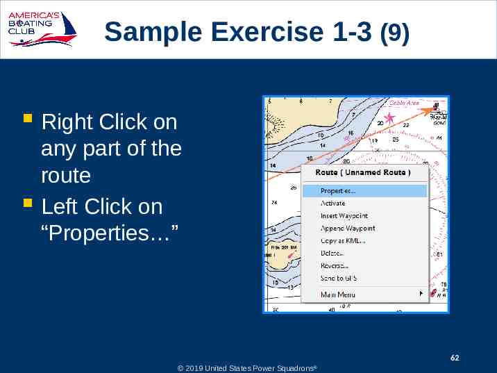
Sample Exercise 1-3 (9) Right Click on any part of the route Left Click on “Properties ” 62 2019 United States Power Squadrons
Sample Exercise 1-3 (10) Route Properties will display total distance and time for the route Also displayed are these references to the next waypoint Distance Estimated travel time Course Latitude Longitude 63 2019 United States Power Squadrons
Sample Exercise 1-3 (e) Open “Route Properties” Top line indicates travel time and distance from Boat Location to RW “OR” Note that it is not included in “Distance” Note that “Enroute” time is the sum of leg 1 and 2 64 2019 United States Power Squadrons
Sample Exercise 1-3 (f) Move the boat to RW “OR” Right Click on the waypoint Hover over Main Menu Left Click “Move Boat Here” Route properties are now easier to read Travel time and distance to starting waypoint RW “OR” are removed 65 2019 United States Power Squadrons
Sample Exercise 1-3 (11) Exercise 1-3 Plot a course from RW “OR” to GC “1” What is: Plot a course from GC “1” to RG “D” What is: Course Direction 344 M Distance 4.7 nm Coordinates of GC “1” L 41 42.0’ N Lo 072 01.4’ W Course Direction 067 M Distance 11.3 nm Coordinates of RG “D” L 41 46.4’ N Lo 071 47.6’ W What is the Total Distance of the Route 15.9 nm 66 2019 United States Power Squadrons