Session HS8.2.9 Spatiotemporal Characteristics and Drivers of
16 Slides4.34 MB
Session HS8.2.9 Spatiotemporal Characteristics and Drivers of Groundwater Change in North China Revealed by GRACE Time-Variable Gravity Tengfei Feng1, Yunzhong Shen1*, Qiujie Chen1, Fengwei Wang1, Xingfu Zhang2 1. College of Surveying and Geo-Informatics, Tongji University (https://gteam.tongji.edu.cn/) 2. Department of Surveying and Mapping, Guangdong University of Technology April 26, 2023
Outline Ⅰ Introduction Ⅱ Data and Methodology Ⅲ GWSA Change and Decomposition Ⅳ Driving Factors Ⅲ Summary
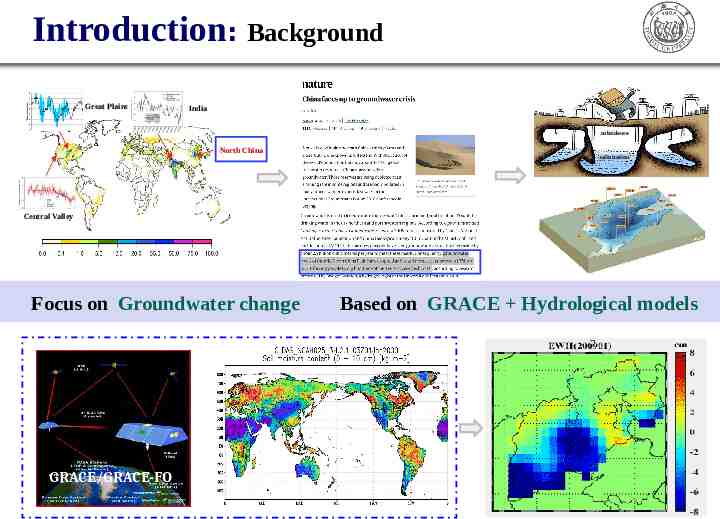
Introduction: Background Great Plains India subsidence North China salinization Central Valley Focus on Groundwater change GRACE/GRACE-FO Based on GRACE Hydrological models
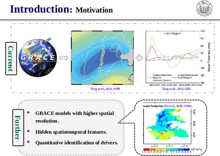
Introduction: Motivation Current Feng et al., 2013, WRR Tang et al., 2013, GRL water footprint (Su et al., 2020, JOH) Further GRACE models with higher spatial resolution. Hidden spatiotemporal features. Quantitative identification of drivers.
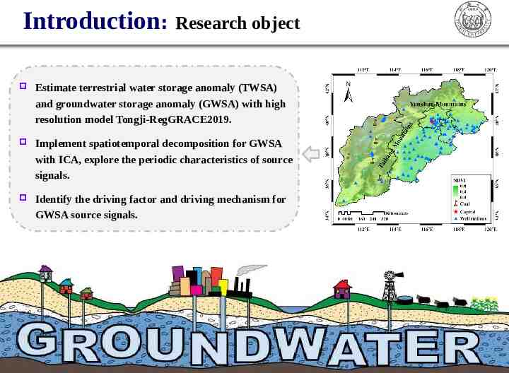
Introduction: Research object Estimate terrestrial water storage anomaly (TWSA) and groundwater storage anomaly (GWSA) with high resolution model Tongji-RegGRACE2019. Implement spatiotemporal decomposition for GWSA with ICA, explore the periodic characteristics of source signals. Identify the driving factor and driving mechanism for GWSA source signals.
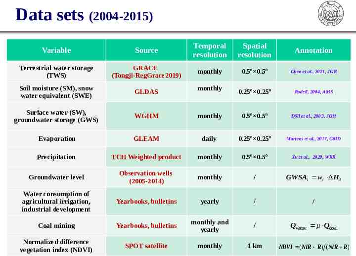
Data sets (2004-2015) Variable Source Temporal resolution Spatial resolution Annotation Terrestrial water storage (TWS) GRACE (Tongji-RegGrace2019) monthly 0.5º 0.5º Chen et al., 2021, JGR Soil moisture (SM), snow water equivalent (SWE) GLDAS 0.25º 0.25º Rodell, 2004, AMS Surface water (SW), groundwater storage (GWS) WGHM monthly 0.5º 0.5º Döll et al., 2003, JOH Evaporation GLEAM daily 0.25º 0.25º Martens et al., 2017, GMD Precipitation TCH Weighted product monthly 0.5º 0.5º Xu et al., 2020, WRR Groundwater level Observation wells (2005-2014) monthly / GWSAi wi ΔH i Water consumption of agricultural irrigation, industrial development Yearbooks, bulletins yearly / / Coal mining Yearbooks, bulletins monthly and yearly / Qwater μ Qcoal Normalized difference vegetation index (NDVI) SPOT satellite monthly 1 km NDVI ( NIR R) ( NIR R) monthly
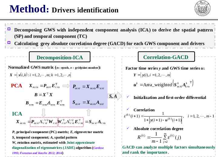
Method: Drivers identification Decomposing GWS with independent component analysis (ICA) to derive the spatial pattern (SP) and temporal component (TC) Calculating grey absolute correlation degree (GACD) for each GWS component and drivers Correlation-GACD Decomposition-ICA Normalized GWS matrix (m : epoch, n : gridpoint number): Factor time series y and GWS time series u: Y y (i ) , i 1, 2, , m X x i, k : i 1, 2, , m; k 1, 2, , n PCA X m n Pm r E rT n Pm r X m n E n r B X T X Bn n E n n n n E u k Area weighted S mk 1 A1k n S, A S m r X m n An r T n n ICA ε 1/ 2 r r X m n Pm r W r rW T r r 1/ 2 r r E T r n (k ) S m r Ar n P, principal component (PC) matrix; E, eigenvector matrix S, temporal component; A, spatial pattern W, rotation matrix, estimated with Joint approximate diagonalization of eigenmatrices (JADE) algorithm (Cardoso 1993; Forootan and Kusche 2012; 2014) T Initialization and first-order differential Correlation 1 (i 1) , i 1, 2, , m 1 (k ) 1 y (i 1) u (i 1) Absolute correlation degree R (k ) 1 m (k ) ε ( j) j m 1 2 GACD can analyze multiple factors simultaneously and rank the importance.
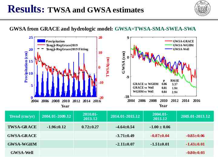
Results: TWSA and GWSA estimates GWSA from GRACE and hydrologic model: GWSA TWSA-SMA-SWEA-SWA 20 10 15 0 10 -10 5 9 0 -20 2004 2006 2008 2010 2012 2014 2016 GWSA (cm) 20 Precipitation Tongji-RegGrace2019 Tongji-RegGrace2019 Fitting TWSA(cm) Precipitation (cm) 25 GWSA-GRACE GWSA-WGHM GWSA-Well 0 -9 p GRACE vs WGHM 0.86 GRACE vs Well 0.81 WGHM vs Well 0.84 RMSE 3.37 1.94 2.94 -18 2004 2006 2008 2010 2012 2014 2016 Year Year Trend (cm/yr) 2004.01-2009.12 2010.012013.12 2014.01-2015.12 2004.012015.12 TWSA-GRACE -1.96 0.12 0.72 0.27 -4.64 0.54 -1.00 0.06 GWSA-GRACE -3.71 0.49 -0.87 0.04 -0.85 0.06 GWSA-WGHM -2.11 0.07 -1.51 0.01 -1.43 0.01 GWSA-Well 2005.01-2013.12 -0.80 0.03
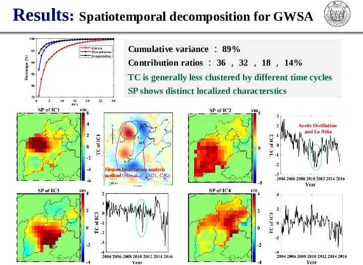
Results: Spatiotemporal decomposition for GWSA 100 GWSA Precipitation Evaporation Percentages (%) 95 90 Contribution ratios : 36 , 32 , 18 , 14% TC is generally less clustered by different time cycles SP shows distinct localized characterstics 85 80 75 Cumulative variance : 89% 0 5 10 15 20 25 30 PCs Arctic Oscillation and La Niña Slepian localization analysis method (Han et al., 2021, CJG)
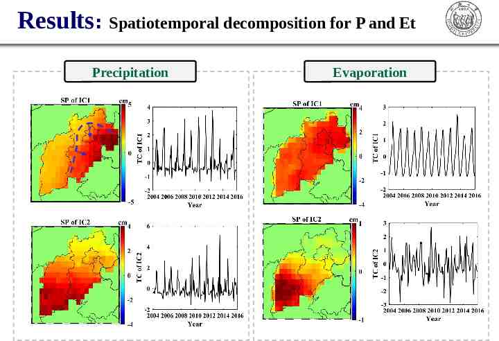
Results: Spatiotemporal decomposition for P and Et Precipitation Evaporation
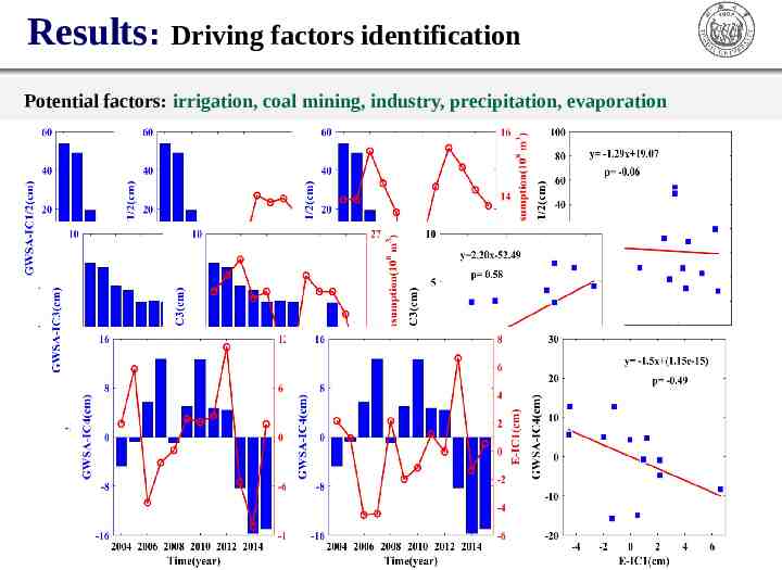
Results: Driving factors identification Potential factors: irrigation, coal mining, industry, precipitation, evaporation
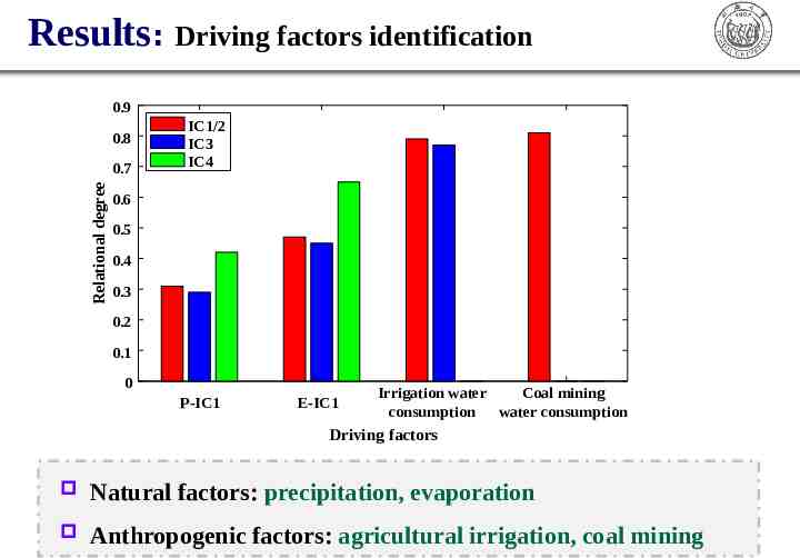
Results: Driving factors identification 0.9 0.8 Relational degree 0.7 IC1/2 IC3 IC4 0.6 0.5 0.4 0.3 0.2 0.1 0 P-IC1 E-IC1 Irrigation water Coal mining consumption water consumption Driving factors Natural factors: precipitation, evaporation Anthropogenic factors: agricultural irrigation, coal mining
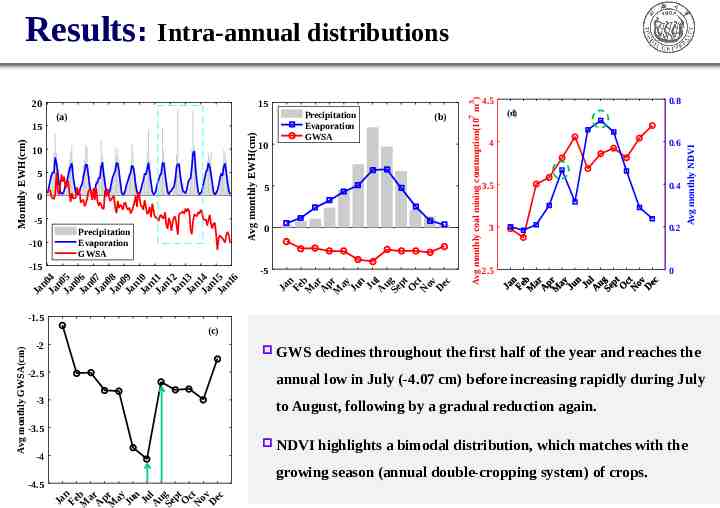
10 5 0 -5 -15 3 (b) 5 0 Ja n Ja 04 n Ja 05 n Ja 06 n Ja 07 n Ja 08 n Ja 09 n Ja 10 n Ja 11 n Ja 12 n Ja 13 n Ja 14 n Ja 15 n1 6 -5 Ja n Fe Mb ar A p Mr ay Ju n Ju A l u Se g pt O c N t ov D ec -10 Precipitation Evaporation GWSA 10 Precipitation Evaporation GWSA 4.5 0.8 (d) 4 0.6 3.5 0.4 3 0.2 2.5 Avg monthly NDVI (a) Avg monthly EWH(cm) Monthly EWH(cm) 15 15 7 20 Avg monthly coal mining consumption(10 m ) Results: Intra-annual distributions 0 -1.5 -2 GWS -2.5 declines throughout the first half of the year and reaches the annual low in July (-4.07 cm) before increasing rapidly during July -3 to August, following by a gradual reduction again. -3.5 NDVI -4 highlights a bimodal distribution, which matches with the growing season (annual double-cropping system) of crops. -4.5 Ja n Fe b M a Ar p Mr ay Ju n Ju A l u Se g pt O c No t v De c Avg monthly GWSA(cm) (c)
Summary GWS derived from Tongji-RegGRACE2019 in North China is depleted with a rate of -0.87 0.04 cm/yr from Jan. 2004 to Dec. 2015, which is basically consistent with that from monitoring well. By ICA decomposition, the temporal components of GWSA present significant annual or intra-annual cycles, and the spatial pattern has distinct localized characteristics, which is helpful for identificating source signal. The driving factors, including uneven spatiotemporal distribution of precipitation, intense seasonal evaporation, severe loss by coal mining, coupled with exhaustive exploitation for irrigation, jointly restrict the GWS rise and fall at different time nodes. Feng, T., Shen, Y., Chen, Q., Wang, F., Zhang, X. (2022). Groundwater storage change and driving factor analysis in North China using independent component decomposition. J. Hydrol., 609, 127708, doi: 10.1016/j.jhydrol.2022.127708.
Major references Feng, W., Zhong, M., Lemoine, J. M., Biancale, R., Hsu, H. T., Xia, J., 2013. Evaluation of groundwater depletion in North China using the gravity recovery and climate experiment (GRACE) data and ground-based measurements. Water Resour. Res. 49(4), 2110-2118. Forootan, E., Kusche, J., 2012. Separation of global time-variable gravity signals into maximally independent components. J. Geod. 86(7), 477-497. Forootan, E., Kusche, J., Loth, I., Schuh, W. D., 2014. Multivariate prediction of total water storage changes over west Africa from multi-satellite data. Surv. Geophys. 35(4), 913-940. Han, J., Chen, S., Lu, H., Xu, W., 2021. Time-variable gravity field determination using Slepian functions and terrestrial measurements: A case study in North China with data from 2011 to 2013. Chin. J. Geophys. (in Chinese) 64(5), 1542-1557. Liu, B., Dai, W., Liu, N., 2017. Extracting seasonal deformations of the Nepal Himalaya region from vertical GPS position time series using independent component analysis. Adv. Space Res., 60, 29102917. Mei, Z. G., 1992. The concept and computation method of grey absolute correlation degree. Systems Engineering (in Chinese) 10, 43-44. Tang, Q., Zhang, X., Yin, T., 2013. Anthropogenic impacts on mass change in North China. Geophs. Res. Lett. 40, 3924-3928.
Thank you for your attention ! Spatiotemporal Characteristics and Drivers of Groundwater Change in North China Revealed by GRACE Time-Variable Gravity Field Tengfei Feng1, Yunzhong Shen1, Qiujie Chen1, Fengwei Wang1, Xingfu Zhang2 1. College of Surveying and Geo-Informatics, Tongji University 2. Department of Surveying and Mapping, Guangdong University of Technology April 26, 2023 https://gteam.tongji.edu.cn/