H070 H470Topic TopicTitle Title © OCR 2017


65 Slides2.78 MB
H070 H470Topic TopicTitle Title OCR 2017
Guide to the SAMs Component 1 – Physical systems OCR 2017
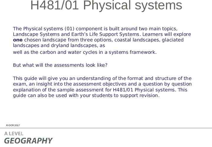
H481/01 Physical systems The Physical systems (01) component is built around two main topics, Landscape Systems and Earth’s Life Support Systems. Learners will explore one chosen landscape from three options, coastal landscapes, glaciated landscapes and dryland landscapes, as well as the carbon and water cycles in a systems framework. But what will the assessments look like? This guide will give you an understanding of the format and structure of the exam, an insight into the assessment objectives and a question by question explanation of the sample assessment for H481/01 Physical systems. This guide can also be used with your students to support revision. OCR 2017
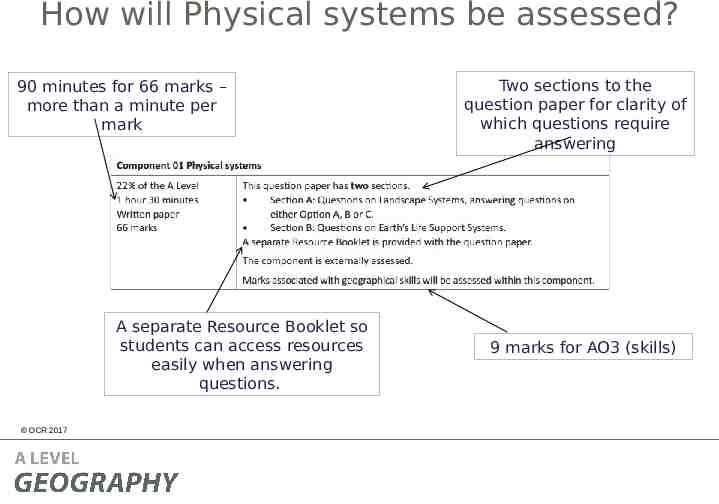
How will Physical systems be assessed? 90 minutes for 66 marks – more than a minute per mark A separate Resource Booklet so students can access resources easily when answering questions. OCR 2017 Two sections to the question paper for clarity of which questions require answering 9 marks for AO3 (skills)
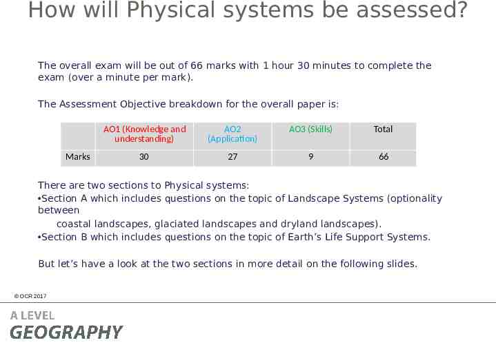
How will Physical systems be assessed? The overall exam will be out of 66 marks with 1 hour 30 minutes to complete the exam (over a minute per mark). The Assessment Objective breakdown for the overall paper is: Marks AO1 (Knowledge and understanding) AO2 (Application) AO3 (Skills) Total 30 27 9 66 There are two sections to Physical systems: Section A which includes questions on the topic of Landscape Systems (optionality between coastal landscapes, glaciated landscapes and dryland landscapes). Section B which includes questions on the topic of Earth’s Life Support Systems. But let’s have a look at the two sections in more detail on the following slides. OCR 2017
Physical systems – Sections A and B Both Section A (Landscape Systems) and Section B (Earth’s Life Support Systems) will have 33 marks in each section of the exam. Each section will include: low tariff, point marked questions (between 1 and 4 mark questions) medium length questions (between 6 and 10 marks), a higher tariff extended response question of 16 marks. In Sections A and B there will be questions on each assessment objective with the following totals across the two sections: Marks AO1 (Knowledge and understanding) AO2 (Application) AO3 (Skills) Total 30 27 9 66 The assessment objectives will not be split evenly between the two sections. OCR 2017
Quality of Extended Responses ‘Quality of extended response’ is assessed within each level for questions of 16 marks or above and is indicated by an asterisk (*) beside the question. The following are the descriptors placed within the levels for 16 mark questions: Level 3 There is a well-developed line of reasoning which is clear and logically structured. The information presented is relevant and substantiated. Level 2 There is a line of reasoning presented with some structure. The information presented is in the most-part relevant and supported by some evidence. Level 1 The information is basic and communicated in an unstructured way. The information is supported by limited evidence and the relationship to the evidence may not be clear. The way that a student has structured their response would need to be considered when you are deciding which level to place the student in – but the quality of the geographical content within the answer should always be the most important consideration. OCR 2017
Level of Response Questions Marking Guidance At the beginning of each mark scheme the following table is included to help you understand the level of response mark schemes – this is for any level marked questions (6 marks and above). The wording in each level (from basic to comprehensive) indicates how answers develop and progress within each assessment objective.
Level of Response Question Mark Scheme A statement to indicate the level of development for answers to reach each level – the wording in the level descriptors are from the marking guidance on slide 10. If ‘Quality of Extended Responses’ and/or ‘place-specific detail’ are being assessed they will be shown in the answer column (Quality of Extended Responses OCR 2017 information will be after the AO2 criteria). The ‘Answer’ column includes information on how the assessment objectives link to the question and the standard required for the question parts. The ‘Indicative content’ part of the mark scheme shows some of the content which could be included in students’ answers. This is not an exhaustive list. In the ‘Guidance’ column there are examples of information that students could discuss in their answers, split by assessment objective. The list is not exhaustive and students should be rewarded for any appropriate content in
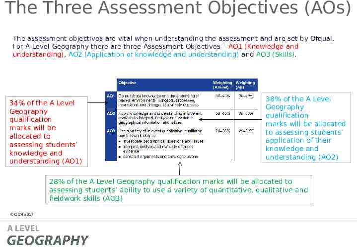
The Three Assessment Objectives (AOs) The assessment objectives are vital when understanding the assessment and are set by Ofqual. For A Level Geography there are three Assessment Objectives – AO1 (Knowledge and understanding), AO2 (Application of knowledge and understanding) and AO3 (Skills). 34% of the A Level Geography qualification marks will be allocated to assessing students’ knowledge and understanding (AO1) 38% of the A Level Geography qualification marks will be allocated to assessing students’ application of their knowledge and understanding (AO2) 28% of the A Level Geography qualification marks will be allocated to assessing students’ ability to use a variety of quantitative, qualitative and fieldwork skills (AO3) OCR 2017
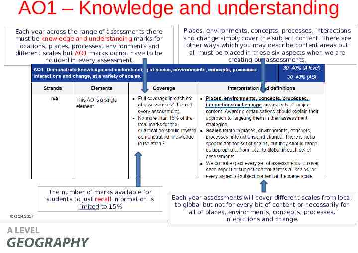
AO1 – Knowledge and understanding Each year across the range of assessments there must be knowledge and understanding marks for locations, places, processes, environments and different scales but AO1 marks do not have to be included in every assessment. The number of marks available for students to just recall information is limited to 15% OCR 2017 Places, environments, concepts, processes, interactions and change simply cover the subject content. There are other ways which you may describe content areas but all must be placed in these six aspects when we are creating our assessments. Each year assessments will cover different scales from local to global but not for every bit of content or necessarily for all of places, environments, concepts, processes, interactions and change.
AO1 command words AO1 requires students to demonstrate knowledge and understanding of the specification content, recalling information – including in a case study context. Questions which target AO1 alone would tend to be shorter answer questions but longer questions may have AO1 marks allocated to them as well when combined with another assessment objective – particularly with AO2. Questions with AO1 marks will require knowledge and understanding – although there may be some marks available for simple recall of information within questions. Explain is the most common command word which requires students to just show knowledge and understanding. Knowledge and understanding will also be required in all ‘essay’ questions of 16 marks and above (where quality of extended response is considered). OCR 2017
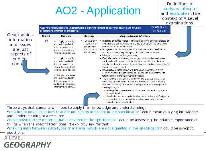
AO2 - Application Definitions of analyse, interpret and evaluate in the context of A Level examinations Geographical information and issues are just aspects of subject content Three ways that students will need to apply their knowledge and understanding: ‘relating to novel situations that are not clearly indicated in the specification’ could mean applying knowledge and understanding to a resource ‘developing further material that is covered in the specification’ could be assessing the relative importance of things when the specification doesn’t explicitly ask for that OCR 2017 links between such types of material which are not signalled in the specification’ could be synoptic ‘making questions.
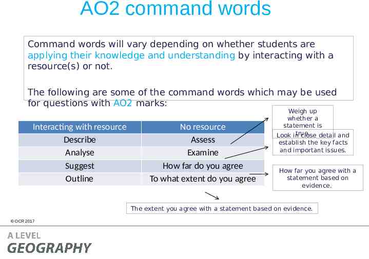
AO2 command words Command words will vary depending on whether students are applying their knowledge and understanding by interacting with a resource(s) or not. The following are some of the command words which may be used for questions with AO2 marks: Interacting with resource Describe Analyse Suggest Outline No resource Assess Examine How far do you agree To what extent do you agree Weigh up whether a statement is true. Look in close detail and establish the key facts and important issues. How far you agree with a statement based on evidence. The extent you agree with a statement based on evidence. OCR 2017
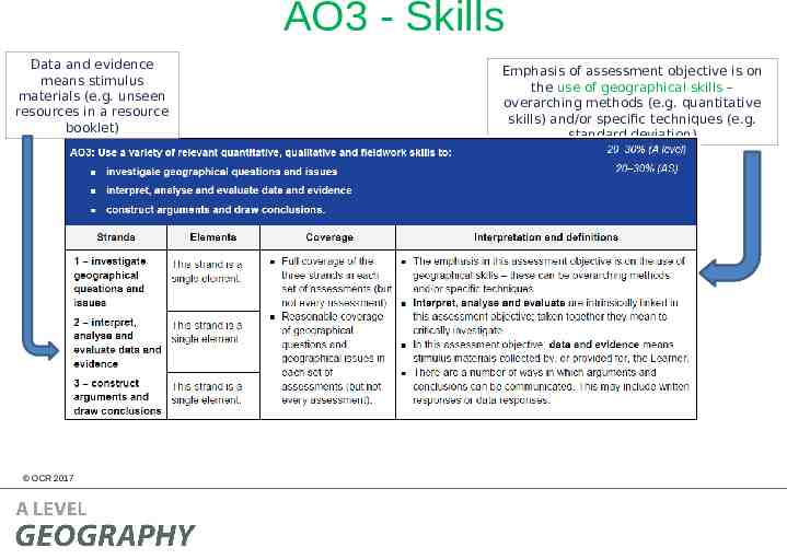
AO3 - Skills Data and evidence means stimulus materials (e.g. unseen resources in a resource booklet) OCR 2017 Emphasis of assessment objective is on the use of geographical skills – overarching methods (e.g. quantitative skills) and/or specific techniques (e.g. standard deviation)
AO3 command words AO3 requires students to use a variety of relevant quantitative, qualitative and fieldwork skills, in order to: investigate geographical questions and issues interpret, analyse and evaluate data and evidence construct arguments and draw conclusions. The following are some of the command words which may be used for questions with AO3 marks: – Compare and contrast – Using evidence from Commands words may vary depending on the – Suggest level of interaction with a – Calculate resource. OCR 2017
Section A The three options in Section A will always have an identical structure so that they are comparable. In the SAMs, all three options had a 2 mark AO3 question, a 3 mark AO2 question, a 4 mark AO3 question, an 8 mark AO1 question and a 16 mark question split between AO1 and AO2. This structure is not the same as in Section B and is not necessarily the same structure which will be used in future examinations. However there will always be a combination of low tariff, point marked questions (between 1 and 4 mark questions) and medium length questions (between 6 and 10 marks), and a higher tariff extended response question of 16 marks. OCR 2017
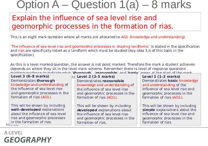
Option A – Question 1(a) – 8 marks Explain the influence of sea level rise and geomorphic processes in the formation of rias. This is an eight mark question where all marks are allocated to AO1 (knowledge and understanding). ‘The influence of sea level rise and geomorphic processes in shaping landforms’ is stated in the specification and rias are specifically listed as a landform which must be studied (key idea 3.b of this topic in the specification). As this is a level marked question, the answer is not point marked. Therefore the mark a student achieves depends on where they sit in the level mark scheme. Remember there is level of response questions marking guidance to indicate what ‘thorough’, ‘reasonable’ and ‘basic’ mean at the start of the mark Level 3 (6–8 Level 1 (1–2 marks) Level 2 (3–5 marks) schemes (and marks) slide 8 of this presentation). Demonstrates thorough Demonstrates basic knowledge Demonstrates reasonable knowledge and understanding of and understanding of the knowledge and understanding of the influence of sea level rise influence of sea level rise and the influence of sea level rise and geomorphic processes in the geomorphic processes in the and geomorphic processes in the formation of rias (AO1). formation of rias (AO1). formation of rias (AO1). This will be shown by including well-developed explanations about the influence of sea level rise and geomorphic processes in the formation of rias. OCR 2017 This will be shown by including developed explanations about the influence of sea level rise and geomorphic processes in the formation of rias. This will be shown by including simple explanations about the influence of sea level rise and geomorphic processes in the formation of rias.
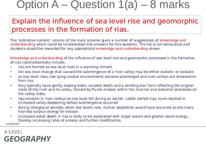
Option A – Question 1(a) – 8 marks Explain the influence of sea level rise and geomorphic processes in the formation of rias. The ‘Indicative content’ column of the mark scheme gives a number of suggestions of knowledge and understanding which could be incorporated into answers for this question. The list is not exhaustive and students should be rewarded for any appropriate knowledge and understanding shown. Knowledge and understanding of the influence of sea level rise and geomorphic processes in the formation of rias could potentially include: rias are formed as sea level rises in a warming climate the sea level change that caused the submergence of a river valley may be either eustatic or isostatic as sea level rises, low–lying coastal environments become submerged and river valleys are drowned to form rias they typically have gently sloping sides, variable depth and a winding plan form reflecting the original route of the river and its valley, formed by fluvial erosion within the channel and subaerial processes on the valley sides rejuvenation in river valleys as sea level fell during an earlier, colder period may have resulted in increased valley deepening before submergence occurred during interglacial periods, when sea levels rose, further deposition would have occurred as the rivers had less surplus energy for erosion increased water depth in rias is likely to be associated with larger waves and greater wave energy, thereby increasing rates of erosion and further modification. OCR 2017
Option A – Question 1(b)(i) – 2 marks Calculate the mean wave height for the data shown in Table 1. You must show your working. This is an AO3 (skills) question where students need to use their statistical skills to calculate the mean wave height for the data shown in Table 1. Working must be shown in order to access both marks. OCR 2017
Option A – Question 1(b)(i) – 2 marks Calculate the mean wave height for the data shown in Table 1. You must show your working. There are two marks available – one mark for the correct answer ( ) and one mark for showing working of calculation (DEV). Formula to calculate the mean of the data: OCR 2017
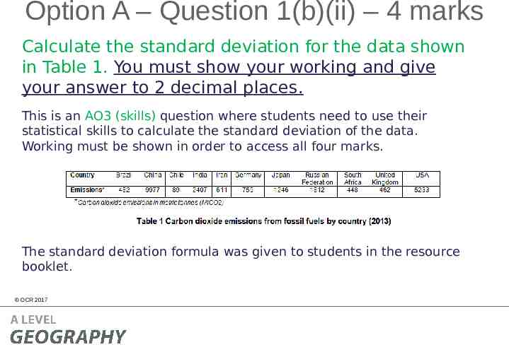
Option A – Question 1(b)(ii) – 4 marks Calculate the standard deviation for the data shown in Table 1. You must show your working and give your answer to 2 decimal places. This is an AO3 (skills) question where students need to use their statistical skills to calculate the standard deviation of the data. Working must be shown in order to access all four marks. The standard deviation formula was given to students in the resource booklet. OCR 2017
Option A – Question 1(b)(ii) – 4 marks Calculate the standard deviation for the data shown in Table 1. You must show your working and give your answer to 2 decimal places. There are four marks available – one mark for calculating differences between data and mean (DEV), one mark for calculating the squares of the differences (DEV), one mark for dividing the sum of the squares of the differences by the number of values in the data set (DEV) and one mark for the correct answer to 2 decimal places ( ). Candidates should be credited for following the standard deviation calculation process using the mean that they calculated in question 1(b)(i). If the candidate calculated the incorrect mean then they should still be rewarded for the standard deviation process.
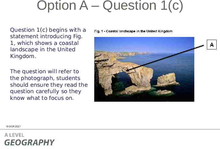
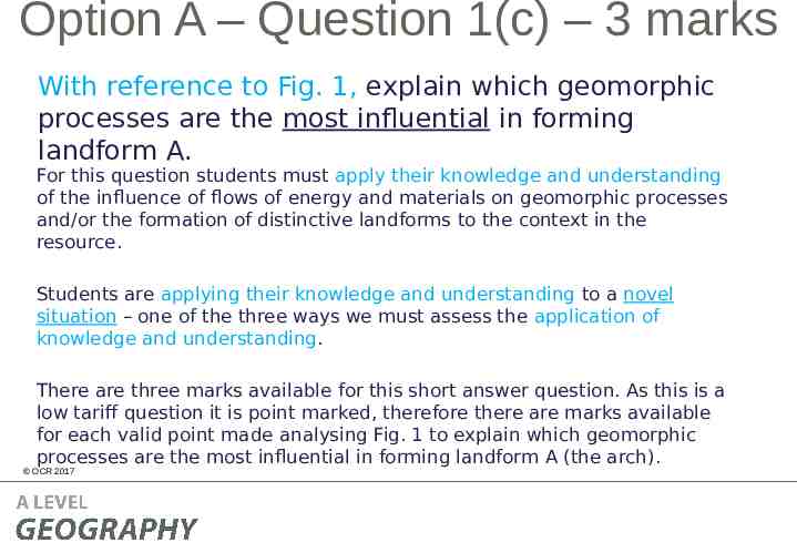
Option A – Question 1(c) Question 1(c) begins with a statement introducing Fig. 1, which shows a coastal landscape in the United Kingdom. The question will refer to the photograph, students should ensure they read the question carefully so they know what to focus on. OCR 2017
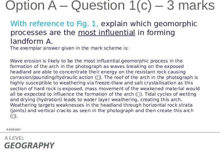
Option A – Question 1(c) – 3 marks With reference to Fig. 1, explain which geomorphic processes are the most influential in forming landform A. For this question students must apply their knowledge and understanding of the influence of flows of energy and materials on geomorphic processes and/or the formation of distinctive landforms to the context in the resource. Students are applying their knowledge and understanding to a novel situation – one of the three ways we must assess the application of knowledge and understanding. There are three marks available for this short answer question. As this is a low tariff question it is point marked, therefore there are marks available for each valid point made analysing Fig. 1 to explain which geomorphic processes are the most influential in forming landform A (the arch). OCR 2017
Option A – Question 1(c) – 3 marks With reference to Fig. 1, explain which geomorphic processes are the most influential in forming landform A. The exemplar answer given in the mark scheme is: Wave erosion is likely to be the most influential geomorphic process in the formation of the arch in the photograph as waves breaking on the exposed headland are able to concentrate their energy on the resistant rock causing corrasion/pounding/hydraulic action ( ). The roof of the arch in the photograph is highly susceptible to weathering via freeze-thaw and salt crystallisation as this section of hard rock is exposed, mass movement of the weakened material would all be expected to influence the formation of the arch ( ). Tidal cycles of wetting and drying (hydration) leads to water layer weathering, creating this arch. Weathering targets weaknesses in the headland through horizontal rock strata (joints) and vertical cracks as seen in the photograph and then create this arch ( ). OCR 2017
Option A – Question 1(d)* – 16 marks ‘Human activity influences coastal landscape systems more than physical factors’. To what extent do you agree with this statement? The final question for all topics in Sections A and B of the Physical systems (01) question paper will always be a 16 mark question which will have 8 marks allocated to AO1 (knowledge and understanding) and 8 marks allocated to AO2 (application of knowledge and understanding). This question requires knowledge and understanding (AO1 8 marks) of the influence of human activity and physical factors in coastal landscape systems (key ideas 2.b, 4.a and 4.b of this topic in the specification). For higher tariff extended response questions (16 marks and over) students are expected to incorporate case study knowledge as appropriate and for this question the case studies in key ideas 4.a and 4.b are the most obvious to include. However students could include other case study information if appropriate. This question also requires the application of knowledge and understanding (AO2 8 marks) in order to develop further the material covered in the specification – another way we must assess application of knowledge and understanding. The command ‘to what extent do you agree’ and the key words ‘more than’ indicate that students must apply their knowledge and understanding by analysing and evaluating. Students must weigh up information to determine the extent that human activity influences coastal landscape systems more than physical factors. There is no ‘correct’ way in which students should answer this question and the response will very much depend on the case studies covered to determine whether students agree with this statement or not. OCR 2017
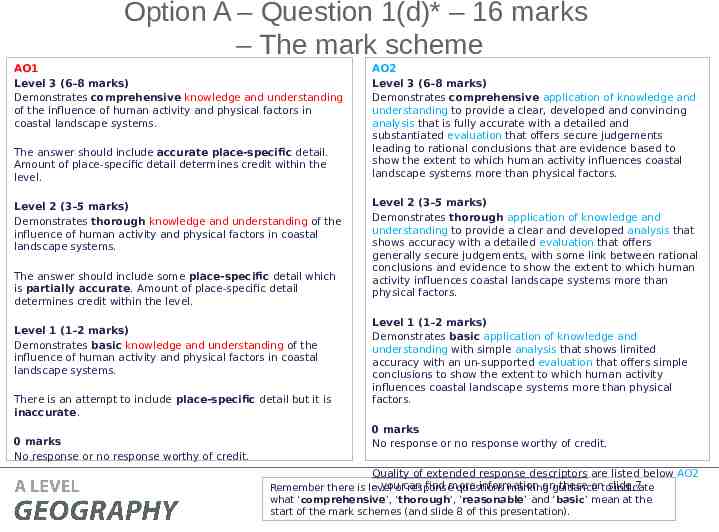
Option A – Question 1(d)* – 16 marks – The mark scheme AO1 Level 3 (6–8 marks) Demonstrates comprehensive knowledge and understanding of the influence of human activity and physical factors in coastal landscape systems. The answer should include accurate place-specific detail. Amount of place-specific detail determines credit within the level. Level 2 (3–5 marks) Demonstrates thorough knowledge and understanding of the influence of human activity and physical factors in coastal landscape systems. The answer should include some place-specific detail which is partially accurate. Amount of place-specific detail determines credit within the level. Level 1 (1–2 marks) Demonstrates basic knowledge and understanding of the influence of human activity and physical factors in coastal landscape systems. There is an attempt to include place-specific detail but it is inaccurate. 0 marks No response or no response worthy of credit. OCR 2017 AO2 Level 3 (6–8 marks) Demonstrates comprehensive application of knowledge and understanding to provide a clear, developed and convincing analysis that is fully accurate with a detailed and substantiated evaluation that offers secure judgements leading to rational conclusions that are evidence based to show the extent to which human activity influences coastal landscape systems more than physical factors. Level 2 (3–5 marks) Demonstrates thorough application of knowledge and understanding to provide a clear and developed analysis that shows accuracy with a detailed evaluation that offers generally secure judgements, with some link between rational conclusions and evidence to show the extent to which human activity influences coastal landscape systems more than physical factors. Level 1 (1–2 marks) Demonstrates basic application of knowledge and understanding with simple analysis that shows limited accuracy with an un-supported evaluation that offers simple conclusions to show the extent to which human activity influences coastal landscape systems more than physical factors. 0 marks No response or no response worthy of credit. Quality of extended response descriptors are listed below AO2 – youofcan find more information onguidance these ontoslide 7. Remember there is level response questions marking indicate what ‘comprehensive’, ‘thorough’, ‘reasonable’ and ‘basic’ mean at the start of the mark schemes (and slide 8 of this presentation).
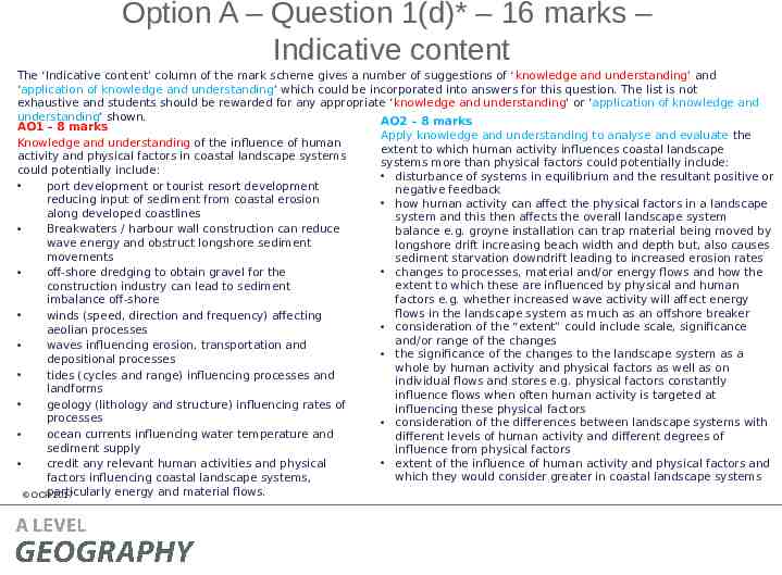
Option A – Question 1(d)* – 16 marks – Indicative content The ‘Indicative content’ column of the mark scheme gives a number of suggestions of ‘knowledge and understanding’ and ‘application of knowledge and understanding’ which could be incorporated into answers for this question. The list is not exhaustive and students should be rewarded for any appropriate ‘knowledge and understanding’ or ‘application of knowledge and understanding’ shown. AO2 – 8 marks AO1 – 8 marks Apply knowledge and understanding to analyse and evaluate the Knowledge and understanding of the influence of human extent to which human activity influences coastal landscape activity and physical factors in coastal landscape systems systems more than physical factors could potentially include: could potentially include: disturbance of systems in equilibrium and the resultant positive or port development or tourist resort development negative feedback reducing input of sediment from coastal erosion how human activity can affect the physical factors in a landscape along developed coastlines system and this then affects the overall landscape system Breakwaters / harbour wall construction can reduce balance e.g. groyne installation can trap material being moved by wave energy and obstruct longshore sediment longshore drift increasing beach width and depth but, also causes movements sediment starvation downdrift leading to increased erosion rates changes to processes, material and/or energy flows and how the off-shore dredging to obtain gravel for the extent to which these are influenced by physical and human construction industry can lead to sediment factors e.g. whether increased wave activity will affect energy imbalance off-shore flows in the landscape system as much as an offshore breaker winds (speed, direction and frequency) affecting consideration of the “extent” could include scale, significance aeolian processes and/or range of the changes waves influencing erosion, transportation and the significance of the changes to the landscape system as a depositional processes whole by human activity and physical factors as well as on tides (cycles and range) influencing processes and individual flows and stores e.g. physical factors constantly landforms influence flows when often human activity is targeted at geology (lithology and structure) influencing rates of influencing these physical factors processes consideration of the differences between landscape systems with ocean currents influencing water temperature and different levels of human activity and different degrees of sediment supply influence from physical factors extent of the influence of human activity and physical factors and credit any relevant human activities and physical which they would consider greater in coastal landscape systems factors influencing coastal landscape systems, particularly energy and material flows. OCR 2017
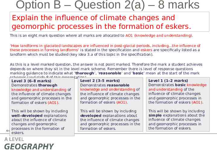
Option B – Question 2(a) – 8 marks Explain the influence of climate changes and geomorphic processes in the formation of eskers. This is an eight mark question where all marks are allocated to AO1 (knowledge and understanding). ‘How landforms in glaciated landscapes are influenced in post-glacial periods, including the influence of these processes in forming landforms’ is stated in the specification and eskers are specifically listed as a landform which must be studied (key idea 3.a of this topic in the specification). As this is a level marked question, the answer is not point marked. Therefore the mark a student achieves depends on where they sit in the level mark scheme. Remember there is level of response questions marking guidance to indicate what ‘thorough’, ‘reasonable’ and ‘basic’ mean at the start of the mark schemes (and slide 8 of this presentation). Level 1 (1–2 marks) Level 2 (3–5 marks) Level 3 (6–8 marks) Demonstrates basic knowledge Demonstrates reasonable Demonstrates thorough and understanding of the knowledge and understanding of knowledge and understanding of influence of climate changes the influence of climate changes the influence of climate changes and geomorphic processes in and geomorphic processes in the and geomorphic processes in the the formation of eskers (AO1). formation of eskers (AO1). formation of eskers (AO1). This will be shown by including well-developed explanations about the influence of climate changes and geomorphic processes in the formation of OCR 2017 eskers. This will be shown by including developed explanations about the influence of climate changes and geomorphic processes in the formation of eskers. This will be shown by including simple explanations about the influence of climate changes and geomorphic processes in the formation of eskers.
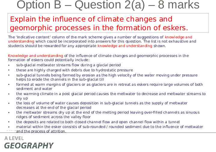
Option B – Question 2(a) – 8 marks Explain the influence of climate changes and geomorphic processes in the formation of eskers. The ‘Indicative content’ column of the mark scheme gives a number of suggestions of knowledge and understanding which could be incorporated into answers for this question. The list is not exhaustive and students should be rewarded for any appropriate knowledge and understanding shown. Knowledge and understanding of the influence of climate changes and geomorphic processes in the formation of eskers could potentially include: sub-glacial meltwater streams flow during a glacial period these are highly charged with debris due to hydrostatic pressure sub-glacial tunnels being formed by erosion as the high velocity of the water moving under pressure helps to erode the channels in the sub-glacial till formed at warm margins of glaciers or as glaciers are in retreat as eskers require large volumes of both sediment and water the warming climate in a post glacial period causes the meltwater to decrease and meltwater streams to dry up the loss of volume of water causes deposition in sub-glacial tunnels as the supply of meltwater decreases at the end of the glacial period the meltwater streams dry up at the end of the melting period leaving over-filled channels as sinuous ridges of sediment across the valley floor the deposits are related to both closed channel flow and open channel flow within a tunnel material within the esker consists of sub-rounded / rounded sediment due to the influence of meltwater OCR 2017 and the process of attrition.
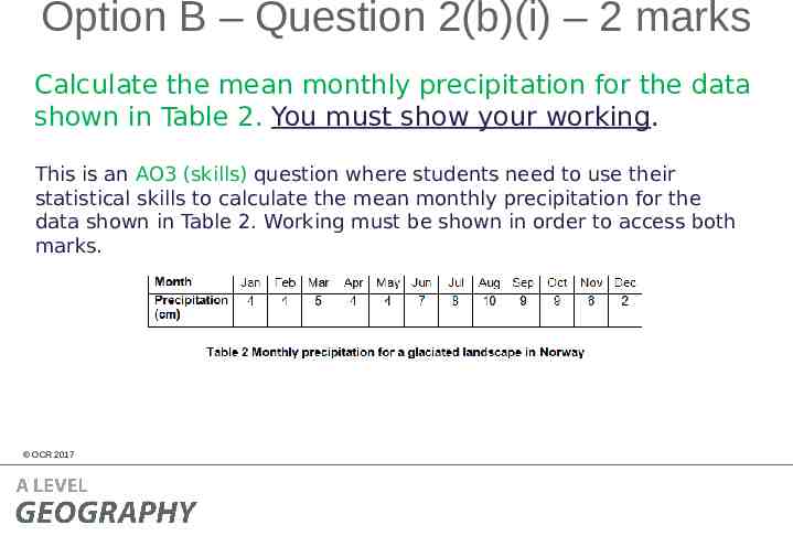
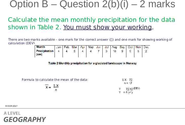
Option B – Question 2(b)(i) – 2 marks Calculate the mean monthly precipitation for the data shown in Table 2. You must show your working. This is an AO3 (skills) question where students need to use their statistical skills to calculate the mean monthly precipitation for the data shown in Table 2. Working must be shown in order to access both marks. OCR 2017
Option B – Question 2(b)(i) – 2 marks Calculate the mean monthly precipitation for the data shown in Table 2. You must show your working. There are two marks available – one mark for the correct answer ( ) and one mark for showing working of calculation (DEV). Formula to calculate the mean of the data: OCR 2017
Option B – Question 2(b)(ii) – 4 marks Calculate the standard deviation for the data shown in Table 2. You must show your working and give your answer to 2 decimal places. This is an AO3 (skills) question where students need to use their statistical skills to calculate the standard deviation of the data. Working must be shown in order to access all four marks. The standard deviation formula was given to students in the resource booklet. OCR 2017
Option B – Question 2(b)(ii) – 4 marks Calculate the standard deviation for the data shown in Table 2. You must show your working and give your answer to 2 decimal places. There are four marks available – one mark for calculating differences between data and mean (DEV), one mark for calculating the squares of the differences (DEV), one mark for dividing the sum of the squares of the differences by the number of values in the data set (DEV) and one mark for the correct answer to 2 decimal places ( ). Candidates should be credited for following the standard deviation calculation process using the mean that they calculated in question 2(b)(i). If the candidate calculated the incorrect mean then they should still be rewarded for the standard deviation process.
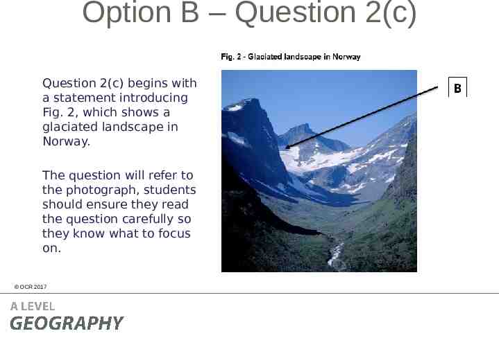
Option B – Question 2(c) Question 2(c) begins with a statement introducing Fig. 2, which shows a glaciated landscape in Norway. The question will refer to the photograph, students should ensure they read the question carefully so they know what to focus on. OCR 2017
Option B – Question 2(c) – 3 marks With reference to Fig. 2, explain which geomorphic processes are the most influential in forming landform B. For this question students must apply their knowledge and understanding of the influence of flows of energy and materials on geomorphic processes and/or the formation of distinctive landforms to the context in the resource. Students are applying their knowledge and understanding to a novel situation – one of the three ways we must assess the application of knowledge and understanding. There are three marks available for this short answer question. As this is a low tariff question it is point marked, therefore there are marks available for each valid point made analysing Fig. 2 to explain which geomorphic processes are the most influential in forming landform B (the corrie). OCR 2017
Option B – Question 2(c) – 3 marks With reference to Fig. 2, explain which geomorphic processes are the most influential in forming landform B. The exemplar answer given in the mark scheme is: Nivation is likely to be the most influential geomorphic process in the initial formation of the corrie as nivation enlarges small hollows, and then ice moves by rotational flow under-weight and gravity ( ). Freeze thaw weathering processes and plucking loosened material from the back of the hollow are important in the landscape shown as there is a steep back wall ( ). Plucked debris from the back wall causes further erosion through abrasion and this is important in creating the distinctive nature of the corrie as it can deepen the hollow creating the armchair shaped hollow evident in the photograph ( ). OCR 2017
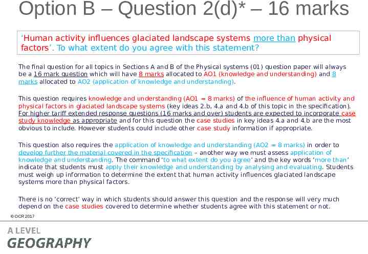
Option B – Question 2(d)* – 16 marks ‘Human activity influences glaciated landscape systems more than physical factors’. To what extent do you agree with this statement? The final question for all topics in Sections A and B of the Physical systems (01) question paper will always be a 16 mark question which will have 8 marks allocated to AO1 (knowledge and understanding) and 8 marks allocated to AO2 (application of knowledge and understanding). This question requires knowledge and understanding (AO1 8 marks) of the influence of human activity and physical factors in glaciated landscape systems (key ideas 2.b, 4.a and 4.b of this topic in the specification). For higher tariff extended response questions (16 marks and over) students are expected to incorporate case study knowledge as appropriate and for this question the case studies in key ideas 4.a and 4.b are the most obvious to include. However students could include other case study information if appropriate. This question also requires the application of knowledge and understanding (AO2 8 marks) in order to develop further the material covered in the specification – another way we must assess application of knowledge and understanding. The command ‘to what extent do you agree’ and the key words ‘more than’ indicate that students must apply their knowledge and understanding by analysing and evaluating. Students must weigh up information to determine the extent that human activity influences glaciated landscape systems more than physical factors. There is no ‘correct’ way in which students should answer this question and the response will very much depend on the case studies covered to determine whether students agree with this statement or not. OCR 2017
Option B – Question 2(d)* – 16 marks – The mark scheme AO1 Level 3 (6–8 marks) Demonstrates comprehensive knowledge and understanding of the influence of human activity and physical factors in glaciated landscape systems. The answer should include accurate place-specific detail. Amount of place-specific detail determines credit within the level. Level 2 (3–5 marks) Demonstrates thorough knowledge and understanding of the influence of human activity and physical factors in glaciated landscape systems. The answer should include some place-specific detail which is partially accurate. Amount of place-specific detail determines credit within the level. Level 1 (1–2 marks) Demonstrates basic knowledge and understanding of the influence of human activity and physical factors in glaciated landscape systems. There is an attempt to include place-specific detail but it is inaccurate. 0 marks No response or no response worthy of credit. OCR 2017 AO2 Level 3 (6–8 marks) Demonstrates comprehensive application of knowledge and understanding to provide a clear, developed and convincing analysis that is fully accurate with a detailed and substantiated evaluation that offers secure judgements leading to rational conclusions that are evidence based to show the extent to which human activity influences glaciated landscape systems more than physical factors. Level 2 (3–5 marks) Demonstrates thorough application of knowledge and understanding to provide a clear and developed analysis that shows accuracy with a detailed evaluation that offers generally secure judgements, with some link between rational conclusions and evidence to show the extent to which human activity influences glaciated landscape systems more than physical factors. Level 1 (1–2 marks) Demonstrates basic application of knowledge and understanding with simple analysis that shows limited accuracy with an un-supported evaluation that offers simple conclusions to show the extent to which human activity influences glaciated landscape systems more than physical factors. 0 marks No response or no response worthy of credit. Quality of extended response descriptors are listed below AO2 – youofcan find more information onguidance these ontoslide 7. Remember there is level response questions marking indicate what ‘comprehensive’, ‘thorough’, ‘reasonable’ and ‘basic’ mean at the start of the mark schemes (and slide 8 of this presentation).
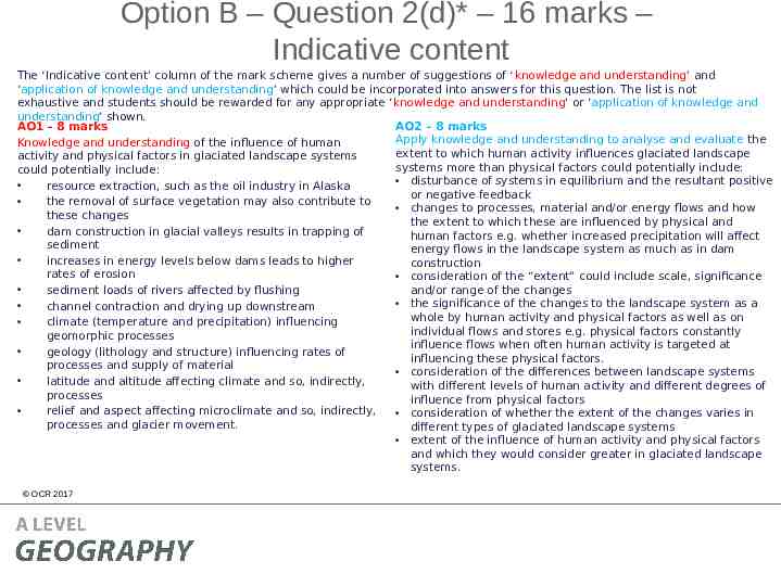
Option B – Question 2(d)* – 16 marks – Indicative content The ‘Indicative content’ column of the mark scheme gives a number of suggestions of ‘knowledge and understanding’ and ‘application of knowledge and understanding’ which could be incorporated into answers for this question. The list is not exhaustive and students should be rewarded for any appropriate ‘knowledge and understanding’ or ‘application of knowledge and understanding’ shown. AO2 – 8 marks AO1 – 8 marks Apply knowledge and understanding to analyse and evaluate the Knowledge and understanding of the influence of human extent to which human activity influences glaciated landscape activity and physical factors in glaciated landscape systems systems more than physical factors could potentially include: could potentially include: disturbance of systems in equilibrium and the resultant positive resource extraction, such as the oil industry in Alaska or negative feedback the removal of surface vegetation may also contribute to changes to processes, material and/or energy flows and how these changes the extent to which these are influenced by physical and dam construction in glacial valleys results in trapping of human factors e.g. whether increased precipitation will affect sediment energy flows in the landscape system as much as in dam increases in energy levels below dams leads to higher construction rates of erosion consideration of the “extent” could include scale, significance and/or range of the changes sediment loads of rivers affected by flushing the significance of the changes to the landscape system as a channel contraction and drying up downstream whole by human activity and physical factors as well as on climate (temperature and precipitation) influencing individual flows and stores e.g. physical factors constantly geomorphic processes influence flows when often human activity is targeted at geology (lithology and structure) influencing rates of influencing these physical factors. processes and supply of material consideration of the differences between landscape systems latitude and altitude affecting climate and so, indirectly, with different levels of human activity and different degrees of processes influence from physical factors relief and aspect affecting microclimate and so, indirectly, consideration of whether the extent of the changes varies in processes and glacier movement. different types of glaciated landscape systems extent of the influence of human activity and physical factors and which they would consider greater in glaciated landscape systems. OCR 2017
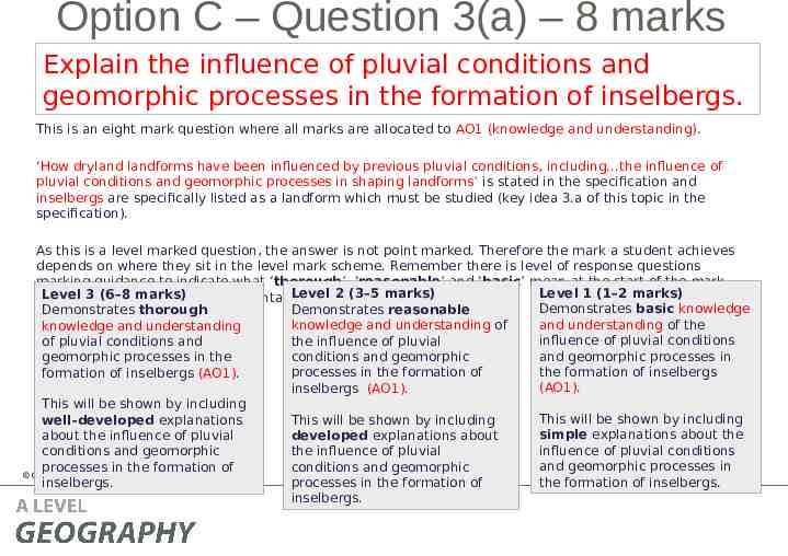
Option C – Question 3(a) – 8 marks Explain the influence of pluvial conditions and geomorphic processes in the formation of inselbergs. This is an eight mark question where all marks are allocated to AO1 (knowledge and understanding). ‘How dryland landforms have been influenced by previous pluvial conditions, including the influence of pluvial conditions and geomorphic processes in shaping landforms’ is stated in the specification and inselbergs are specifically listed as a landform which must be studied (key idea 3.a of this topic in the specification). As this is a level marked question, the answer is not point marked. Therefore the mark a student achieves depends on where they sit in the level mark scheme. Remember there is level of response questions marking guidance to indicate what ‘thorough’, ‘reasonable’ and ‘basic’ mean at the start of the mark Level 1 (1–2 marks) Level 2 (3–5 marks) Level 3 (and (6–8 slide marks) schemes 8 of this presentation). Demonstrates basic knowledge Demonstrates reasonable Demonstrates thorough and understanding of the knowledge and understanding of knowledge and understanding influence of pluvial conditions the influence of pluvial of pluvial conditions and and geomorphic processes in conditions and geomorphic geomorphic processes in the the formation of inselbergs processes in the formation of formation of inselbergs (AO1). (AO1). inselbergs (AO1). This will be shown by including This will be shown by including This will be shown by including well-developed explanations simple explanations about the developed explanations about about the influence of pluvial influence of pluvial conditions the influence of pluvial conditions and geomorphic and geomorphic processes in conditions and geomorphic processes in the formation of OCR 2017 the formation of inselbergs. processes in the formation of inselbergs. inselbergs.
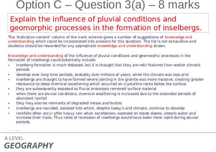
Option C – Question 3(a) – 8 marks Explain the influence of pluvial conditions and geomorphic processes in the formation of inselbergs. The ‘Indicative content’ column of the mark scheme gives a number of suggestions of knowledge and understanding which could be incorporated into answers for this question. The list is not exhaustive and students should be rewarded for any appropriate knowledge and understanding shown. Knowledge and understanding of the influence of pluvial conditions and geomorphic processes in the formation of inselbergs could potentially include: inselberg formation is much debated, but it is thought that they are relic features from wetter climatic periods develop over long time periods, probably over millions of years, when the climate was less arid inselbergs are thought to have formed where jointing in the granite was more massive, creating greater resistance to deep chemical weathering which occurred on crystalline rocks below the surface they are subsequently exposed as fluvial processes removed surface material when there are pluvial conditions, chemical weathering is increased due to the extended periods of abundant rainfall they may also be remnants of degraded mesas and buttes inselbergs are rounded, isolated hills which, despite today’s arid climate, continue to develop rockfalls often occur after heavy rain when sandstones, exposed on steep slopes, absorb water and increase their mass. Thus rates of recession of inselbergs would have been more rapid during pluvial periods. OCR 2017
Option C – Question 3(b)(i) – 2 marks Calculate the mean monthly wind speed for the data shown in Table 3. You must show your working. This is an AO3 (skills) question where students need to use their statistical skills to calculate the mean monthly wind speed for the data shown in Table 3. Working must be shown in order to access both marks. OCR 2017
Option C – Question 3(b)(i) – 2 marks Calculate the mean monthly wind speed for the data shown in Table 3. You must show your working. There are two marks available – one mark for the correct answer ( ) and one mark for showing working of calculation (DEV). Formula to calculate the mean of the data: OCR 2017
Option C – Question 3(b)(ii) – 4 marks Calculate the standard deviation for the data shown in Table 3. You must show your working and give your answer to 2 decimal places. This is an AO3 (skills) question where students need to use their statistical skills to calculate the standard deviation of the data. Working must be shown in order to access all four marks. The standard deviation formula was given to students in the resource booklet. OCR 2017
Option C – Question 3(b)(ii) – 4 marks Calculate the standard deviation for the data shown in Table 2. You must show your working and give your answer to 2 decimal places. There are four marks available – one mark for calculating differences between data and mean (DEV), one mark for calculating the squares of the differences (DEV), one mark for dividing the sum of the squares of the differences by the number of values in the data set (DEV) and one mark for the correct answer to 2 decimal places ( ). Candidates should be credited for following the standard deviation calculation process using the mean that they calculated in question 2(b)(i). If the candidate calculated the incorrect mean then they should still be rewarded for the standard deviation process.
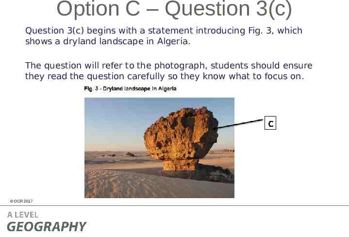
Option C – Question 3(c) Question 3(c) begins with a statement introducing Fig. 3, which shows a dryland landscape in Algeria. The question will refer to the photograph, students should ensure they read the question carefully so they know what to focus on. OCR 2017
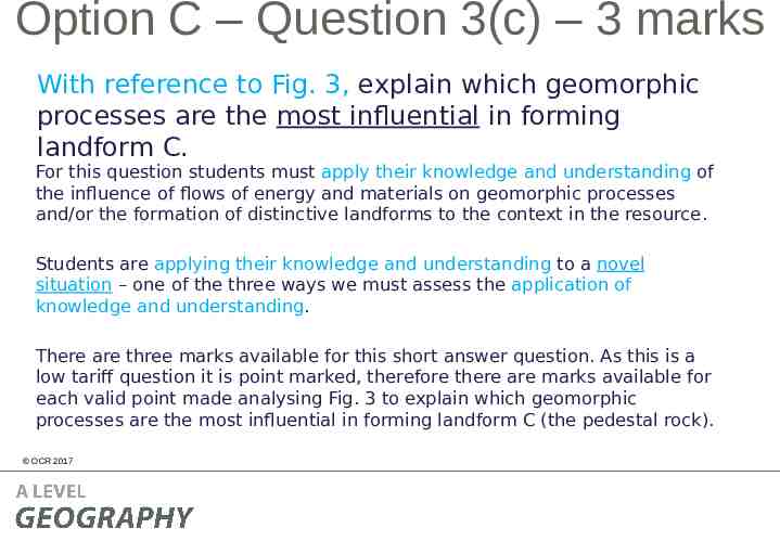
Option C – Question 3(c) – 3 marks With reference to Fig. 3, explain which geomorphic processes are the most influential in forming landform C. For this question students must apply their knowledge and understanding of the influence of flows of energy and materials on geomorphic processes and/or the formation of distinctive landforms to the context in the resource. Students are applying their knowledge and understanding to a novel situation – one of the three ways we must assess the application of knowledge and understanding. There are three marks available for this short answer question. As this is a low tariff question it is point marked, therefore there are marks available for each valid point made analysing Fig. 3 to explain which geomorphic processes are the most influential in forming landform C (the pedestal rock). OCR 2017
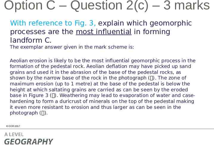
Option C – Question 2(c) – 3 marks With reference to Fig. 3, explain which geomorphic processes are the most influential in forming landform C. The exemplar answer given in the mark scheme is: Aeolian erosion is likely to be the most influential geomorphic process in the formation of the pedestal rock. Aeolian deflation may have picked up sand grains and used it in the abrasion of the base of the pedestal rocks, as shown by the narrow base of the rock in the photograph ( ). The zone of maximum erosion (up to 1 metre) at the base of the pedestal is below the height at which saltating grains are carried as can be seen by the eroded base in Figure 3 ( ). Weathering may lead to evaporation of water and casehardening to form a duricrust of minerals on the top of the pedestal making it even more resistant to erosion and thus larger as can be seen in the photograph ( ). OCR 2017
Option C – Question 3(d)* – 16 marks ‘Human activity influences dryland landscape systems more than physical factors’. To what extent do you agree with this statement? The final question for all topics in Sections A and B of the Physical systems (01) question paper will always be a 16 mark question which will have 8 marks allocated to AO1 (knowledge and understanding) and 8 marks allocated to AO2 (application of knowledge and understanding). This question requires knowledge and understanding (AO1 8 marks) of the influence of human activity and physical factors in dryland landscape systems (key ideas 2.b, 4.a and 4.b of this topic in the specification). For higher tariff extended response questions (16 marks and over) students are expected to incorporate case study knowledge as appropriate and for this question the case studies in key ideas 4.a and 4.b are the most obvious to include. However students could include other case study information if appropriate. This question also requires the application of knowledge and understanding (AO2 8 marks) in order to develop further the material covered in the specification – another way we must assess application of knowledge and understanding. The command ‘to what extent do you agree’ and the key words ‘more than’ indicate that students must apply their knowledge and understanding by analysing and evaluating. Students must weigh up information to determine the extent that human activity influences dryland landscape systems more than physical factors. There is no ‘correct’ way in which students should answer this question and the response will very much depend on the case studies covered to determine whether students agree with this statement or not. OCR 2017
Option C – Question 3(d)* – 16 marks – The mark scheme AO1 Level 3 (6–8 marks) Demonstrates comprehensive knowledge and understanding of the influence of human activity and physical factors in dryland landscape systems. The answer should include accurate place-specific detail. Amount of place-specific detail determines credit within the level. Level 2 (3–5 marks) Demonstrates thorough knowledge and understanding of the influence of human activity and physical factors in dryland landscape systems. The answer should include some place-specific detail which is partially accurate. Amount of place-specific detail determines credit within the level. Level 1 (1–2 marks) Demonstrates basic knowledge and understanding of the influence of human activity and physical factors in dryland landscape systems. There is an attempt to include place-specific detail but it is inaccurate. 0 marks No response or no response worthy of credit. OCR 2017 AO2 Level 3 (6–8 marks) Demonstrates comprehensive application of knowledge and understanding to provide a clear, developed and convincing analysis that is fully accurate with a detailed and substantiated evaluation that offers secure judgements leading to rational conclusions that are evidence based, to show the extent to which human activity influences dryland landscape systems more than physical factors. Level 2 (3–5 marks) Demonstrates thorough application of knowledge and understanding to provide a clear and developed analysis that shows accuracy with a detailed evaluation that offers generally secure judgements, with some link between rational conclusions and evidence, to show the extent to which human activity influences dryland landscape systems more than physical factors. Level 1 (1–2 marks) Demonstrates basic application of knowledge and understanding with simple analysis that shows limited accuracy with an un-supported evaluation that offers simple conclusions, to show the extent to which human activity influences dryland landscape systems more than physical factors. 0 marks No response or no response worthy of credit. Quality of extended response descriptors are listed below AO2 – youofcan find more information onguidance these ontoslide 7. Remember there is level response questions marking indicate what ‘comprehensive’, ‘thorough’, ‘reasonable’ and ‘basic’ mean at the start of the mark schemes (and slide 8 of this presentation).
Option C – Question 3(d)* – 16 marks – Indicative content The ‘Indicative content’ column of the mark scheme gives a number of suggestions of ‘knowledge and understanding’ and ‘application of knowledge and understanding’ which could be incorporated into answers for this question. The list is not exhaustive and students should be rewarded for any appropriate ‘knowledge and understanding’ or ‘application of knowledge and understanding’ shown. AO2 – 8 marks AO1 – 8 marks Apply knowledge and understanding to analyse and evaluate the Knowledge and understanding of the influence of human extent to which human activity influences dryland landscape activity and physical factors in dryland landscape systems systems more than physical factors could potentially include: could potentially include: disturbance of systems in equilibrium and the resultant positive exposed surfaces are subjected to higher erosion rates as or negative feedback there is no protection against aeolian erosion or flash how human activity can affect the physical factors in a floods causing fluvial erosion landscape system and this then affects the overall landscape an increase in loose material in the system and deposition system balance e.g. damage is caused to brittle, fragile may lead to formation of alluvial fans and bajadas cryptobiotic crusts and the sparse vegetation due to activities eroded sediment may then be blown to marginal areas such as dune buggying where it accumulates as loess changes to processes, material and/or energy flows and the water abstraction and dams affect water table levels extent to which these are influenced by physical and human factors e.g. whether increased aeolian erosion will affect energy dams trap sediment and reduce river load flows in the landscape system as much as adventure a decrease in loose material in the system and may lead recreationalists engaging in motorised recreation to degradation of alluvial fans and bajadas consideration of the “extent” could include scale, significance climate (temperature and precipitation) influencing and/or range of the changes geomorphic processes the significance of the changes to the landscape system as a geology (lithology and structure) influencing rates of whole by human activity and physical factors as well as on processes and supply of material individual flows and stores e.g. physical factors constantly latitude and altitude affecting climate and so, indirectly, influence flows when often human activity is targeted at processes influencing these physical factors relief and aspect affecting microclimate and so, indirectly, consideration of the differences between landscape systems processes with different levels of human activity and different degrees of influence from physical factors availability of sediment influencing processes. extent of the influence of human activity and physical factors OCR 2017 and which they would consider greater in dryland landscape systems.
Section B In the SAMs, Section B had a 3 mark AO3 question, a 4 mark AO2 questions, a 10 mark question split between AO1 and AO2 and a 16 mark question split between AO1 and AO2. This structure is not the same as in Section A and is not necessarily the same structure which will be used in future examinations. However there will always be a combination of low tariff, point marked questions (between 1 and 4 mark questions) and medium length questions (between 6 and 10 marks), and a higher tariff extended response question of 16 marks. There is no optionality in Section B. OCR 2017
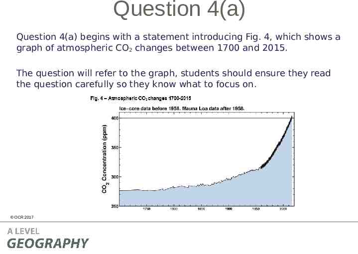
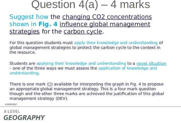
Question 4(a) Question 4(a) begins with a statement introducing Fig. 4, which shows a graph of atmospheric CO2 changes between 1700 and 2015. The question will refer to the graph, students should ensure they read the question carefully so they know what to focus on. OCR 2017
Question 4(a) – 4 marks Suggest how the changing CO2 concentrations shown in Fig. 4 influence global management strategies for the carbon cycle. For this question students must apply their knowledge and understanding of global management strategies to protect the carbon cycle to the context in the resource. Students are applying their knowledge and understanding to a novel situation – one of the three ways we must assess the application of knowledge and understanding. There is one mark ( ) available for interpreting the graph in Fig. 4 to propose an appropriate global management strategy. This is a four mark question though and the other three marks are achieved the justification of this global management strategy (DEV). OCR 2017
Question 4(b)(ii) – 4 marks Suggest how the changing CO2 concentrations shown in Fig. 4 influence global management strategies for the carbon cycle. Any appropriate global management strategy should be rewarded and examples could potentially include wetland restoration ( ), afforestation ( ), sustainable agricultural practices ( ) An example answer for wetland restoration is given in the mark scheme: Wetland restoration could be used to act as a carbon sink as there has been a rapid increase in atmospheric CO2 concentrations ( ). Wetlands act as a sink for carbon since their soils decompose very slowly (DEV) and can store carbon for hundreds or thousands of years (DEV). Degradation of wetlands is a significant source of emissions of carbon dioxide to the atmosphere and so wetland restoration can help limit these emissions (DEV). OCR 2017
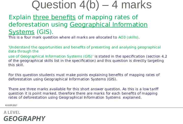
Question 4(b) – 4 marks Explain three benefits of mapping rates of deforestation using Geographical Information Systems (GIS). This is a four mark question where all marks are allocated to AO3 (skills). ‘Understand the opportunities and benefits of presenting and analysing geographical data through the use of Geographical Information Systems (GIS)’ is stated in the specification (section 4.2 of the geographical skills list in the specification) and this question is directly targeting this skill. For this question students must make points explaining benefits of mapping rates of deforestation using Geographical Information Systems (GIS). There are three marks available for this short answer question. As this is a low tariff question it is point marked, therefore there are marks for each benefits of mapping rates of deforestation using Geographical Information Systems explained. OCR 2017
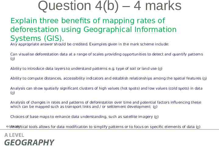
Question 4(b) – 4 marks Explain three benefits of mapping rates of deforestation using Geographical Information Systems (GIS). Any appropriate answer should be credited. Examples given in the mark scheme include: Can visualise deforestation data at a range of scales providing opportunities to detect and quantify patterns ( ) Ability to introduce data layers to understand patterns e.g. type of soil or land use ( ) Ability to compute distances, accessibility indicators and establish relationships among the spatial features ( ) Analysis can show spatially significant clusters of high values (hot spots) and low values (cold spots) in data ( ) Analysis of changes in rates and patterns of deforestation over time and potential factors influencing these which can be mapped such as transport links and / or settlement development ( ) Choices of base maps to enhance data understanding, such as satellite imagery ( ) OCR 2017 Analytical tools allows for data modification to simplify patterns or to focus on specific elements of data ( )
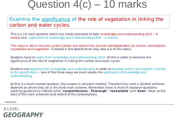
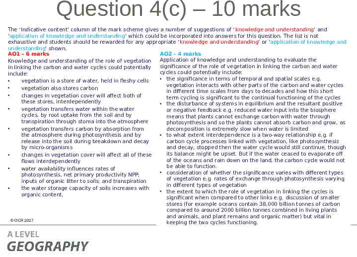
Question 4(c) – 10 marks Examine the significance of the role of vegetation in linking the carbon and water cycles. This is a 10 mark question which has marks allocated to both knowledge and understanding (AO1 – 6 marks) and application of knowledge and understanding (AO2 – 4 marks). ‘The ways in which the two cycles (carbon and water) link and are interdependent via oceans, atmosphere, cryosphere and vegetation’ is stated in the specification (key idea 4.a of this topic). Students have to apply their knowledge and understanding (AO2) of this in order to examine the significance of the role of vegetation in linking the carbon and water cycles. Students are applying their knowledge and understanding in order to develop further the material covered in the specification – one of the three ways we must assess the application of knowledge and understanding. As this is a level marked question, the answer is not point marked. Therefore the mark a student achieves depends on where they sit in the level mark scheme. Remember there is level of response questions marking guidance to indicate what ‘comprehensive’, ‘thorough’, ‘reasonable’ and ‘basic’ mean at the start of the mark schemes (and slide 8 of this presentation). OCR 2017
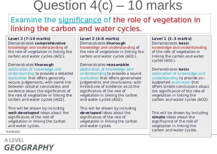
Question 4(c) – 10 marks Examine the significance of the role of vegetation in linking the carbon and water cycles. Level 3 (7–10 marks) Demonstrates comprehensive knowledge and understanding of the role of vegetation in linking the carbon and water cycles (AO1). Level 2 (4-6 marks) Demonstrates thorough knowledge and understanding of the role of vegetation in linking the carbon and water cycles (AO1). Demonstrates thorough application of knowledge and understanding to provide a detailed evaluation that offers generally secure judgements, with some link between rational conclusions and evidence about the significance of the role of vegetation in linking the carbon and water cycles (AO2). Demonstrates reasonable application of knowledge and understanding to provide a sound evaluation that offers generalised judgements and conclusions, with limited use of evidence as to the significance of the role of vegetation in linking the carbon and water cycles (AO2). This will be shown by including well-developed ideas about the significance of the role of vegetation in linking the carbon and water cycles. This will be shown by including developed ideas about the significance of the role of vegetation in linking the carbon and water cycles. OCR 2017 Level 1 (1–3 marks) Demonstrates basic knowledge and understanding of the role of vegetation in linking the carbon and water cycles (AO1). Demonstrates basic application of knowledge and understanding to provide unsupported evaluation that offers simple conclusions about the significance of the role of vegetation in linking the carbon and water cycles (AO2). This will be shown by including simple ideas about the significance of the role of vegetation in linking the carbon and water cycles.
Question 4(c) – 10 marks The ‘Indicative content’ column of the mark scheme gives a number of suggestions of ‘knowledge and understanding’ and ‘application of knowledge and understanding’ which could be incorporated into answers for this question. The list is not exhaustive and students should be rewarded for any appropriate ‘knowledge and understanding’ or ‘application of knowledge and understanding’ shown. AO2 – 4 marks AO1 – 6 marks Application of knowledge and understanding to evaluate the Knowledge and understanding of the role of vegetation significance of the role of vegetation in linking the carbon and water in linking the carbon and water cycles could potentially cycles could potentially include: include: the significance in terms of temporal and spatial scales e.g. vegetation is a store of water, held in fleshy cells vegetation interacts with other parts of the carbon and water cycles vegetation also stores carbon in different time scales from days to decades and how this short changes in vegetation cover will affect both of term cycling is significant to the continual functioning of the cycles these stores, interdependently the disturbance of systems in equilibrium and the resultant positive vegetation transfers water within the water or negative feedback e.g. reduced water input into the biosphere cycles, by root uptake from the soil and by means that plants cannot exchange carbon with water through transpiration through stoma into the atmosphere photosynthesis and so the plants cannot absorb carbon and grow, as vegetation transfers carbon by absorption from decomposition is extremely slow when water is limited to what extent interdependence is a two-way relationship e.g. if the atmosphere during photosynthesis and by carbon cycle processes linked with vegetation, like photosynthesis release into the soil during breakdown and decay by micro-organisms and decay, stopped then the water cycle would still continue, though its balance might be upset. But if the water ceased to evaporate off changes in vegetation cover will affect all of these of the oceans and rain down on the land, the carbon cycle would not flows interdependently be able to function. water availability influences rates of consideration of whether the significance varies with different types photosynthesis, net primary productivity NPP; of vegetation e.g. rates of exchange through photosynthesis varying inputs of organic litter to soils; and transpiration in different types of vegetation the water storage capacity of soils increases with the extent to which the role of vegetation in linking the cycles is organic content. significant when compared to other links e.g. discussion of smaller stores (for example oceans contain 38,000 billion tonnes of carbon compared to around 2000 billion tonnes combined in living plants and animals, and plant remains and organic matter) but vital in OCR 2017 keeping the two cycles functioning.
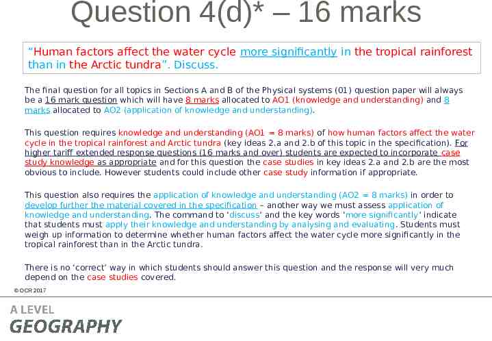
Question 4(d)* – 16 marks “Human factors affect the water cycle more significantly in the tropical rainforest than in the Arctic tundra”. Discuss. The final question for all topics in Sections A and B of the Physical systems (01) question paper will always be a 16 mark question which will have 8 marks allocated to AO1 (knowledge and understanding) and 8 marks allocated to AO2 (application of knowledge and understanding). This question requires knowledge and understanding (AO1 8 marks) of how human factors affect the water cycle in the tropical rainforest and Arctic tundra (key ideas 2.a and 2.b of this topic in the specification). For higher tariff extended response questions (16 marks and over) students are expected to incorporate case study knowledge as appropriate and for this question the case studies in key ideas 2.a and 2.b are the most obvious to include. However students could include other case study information if appropriate. This question also requires the application of knowledge and understanding (AO2 8 marks) in order to develop further the material covered in the specification – another way we must assess application of knowledge and understanding. The command to ‘discuss’ and the key words ‘more significantly’ indicate that students must apply their knowledge and understanding by analysing and evaluating. Students must weigh up information to determine whether human factors affect the water cycle more significantly in the tropical rainforest than in the Arctic tundra. There is no ‘correct’ way in which students should answer this question and the response will very much depend on the case studies covered. OCR 2017
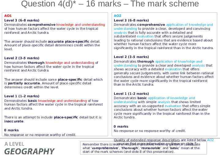
Question 4(d)* – 16 marks – The mark scheme AO1 Level 3 (6–8 marks) Demonstrates comprehensive knowledge and understanding of how human factors affect the water cycle in the tropical rainforest and Arctic tundra. The answer should include accurate place-specific detail. Amount of place-specific detail determines credit within the level. Level 2 (3–5 marks) Demonstrates thorough knowledge and understanding of how human factors affect the water cycle in the tropical rainforest and Arctic tundra. The answer should include some place-specific detail which is partially accurate. Amount of place-specific detail determines credit within the level. Level 1 (1–2 marks) Demonstrates basic knowledge and understanding of how human factors affect the water cycle in the tropical rainforest and Arctic tundra. There is an attempt to include place-specific detail but it is inaccurate. 0 marks No response or no response worthy of credit. OCR 2017 AO2 Level 3 (6–8 marks) Demonstrates comprehensive application of knowledge and understanding to provide a clear, developed and convincing analysis that is fully accurate with a detailed and substantiated evaluation that offers secure judgements leading to rational conclusions that are evidence based about whether human factors affect the water cycle more significantly in the tropical rainforest than in the Arctic tundra. Level 2 (3–5 marks) Demonstrates thorough application of knowledge and understanding to provide a clear and developed analysis that shows accuracy with a detailed evaluation that offers generally secure judgements, with some link between rational conclusions and evidence about whether human factors affect the water cycle more significantly in the tropical rainforest than in the Arctic tundra. Level 1 (1–2 marks) Demonstrates basic application of knowledge and understanding with simple analysis that shows limited accuracy with an un-supported evaluation that offers simple conclusions about whether human factors affect the water cycle more significantly in the tropical rainforest than in the Arctic tundra. 0 marks No response or no response worthy of credit. Quality of extended response descriptors are listed below AO2 – youofcan find more information onguidance these ontoslide 7. Remember there is level response questions marking indicate what ‘comprehensive’, ‘thorough’, ‘reasonable’ and ‘basic’ mean at the start of the mark schemes (and slide 8 of this presentation).
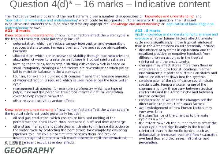
Question 4(d)* – 16 marks – Indicative content The ‘Indicative content’ column of the mark scheme gives a number of suggestions of ‘knowledge and understanding’ and ‘application of knowledge and understanding’ which could be incorporated into answers for this question. The list is not exhaustive and students should be rewarded for any appropriate ‘knowledge and understanding’ or ‘application of knowledge and understanding’ shown. AO2 – 8 marks AO1 – 8 marks Apply knowledge and understanding to analyse and Knowledge and understanding of how human factors affect the water cycle in evaluate whether human factors affect the water the tropical rainforest could potentially include: cycle more significantly in the tropical rainforest deforestation, which can reduce canopy interception and evaporation, than in the Arctic tundra could potentially include: reduces water storage, increase overland flow and reduce atmospheric disturbance of systems in equilibrium and the humidity resultant positive or negative feedback from afforestation, which can increase soil stability through root networks and different human activities in the tropical absorption of water to create dense foliage in tropical rainforest areas rainforest and the arctic tundra farming techniques, for example shifting cultivation which is based on changes may affect stores more than flows or small, temporary clearings where forests are re-established when yields vice versa e.g. how tourist locations in either fall to maintain balance in the water cycle environment put additional strains on stores and tourism, for example building golf courses means that massive amounts introduce different flows into the systems of water extraction is required which causes imbalances the local water consideration of the significance could include cycle spatial scale, temporal scale, range of the changes and how these vary between tropical management strategies, for example agroforestry which is a type of rainforests and the Arctic tundra and between polyculture and the perennial tree crops maintain natural vegetation cover to help recycle rainwater human activities consideration of whether the changes are the other relevant activities and/or effects. direct or indirect result of human factors acknowledgement of how human factors may Knowledge and understanding of how human factors affect the water cycle in vary over time the tropical rainforest could potentially include: the significance of the changes to the water oil and gas production, which can cause localised melting of the cycle as a whole permafrost and snow cover, thus increased run off and river discharge the extent to which the human factors affect the oil and gas management strategies, which aim to minimise disruption to water cycle more significantly in the tropical the water cycle by protecting the permafrost, for example by elevating rainforest than in the Arctic tundra, such as OCR 2017 pipelines to allow cold air to circulate beneath them and provide deforestation increases overland flow / saturated insulation against the heat which would otherwise melt the permafrost overland flow and decreases infiltration and percolation. other relevant activities and/or effects.